Get widget

News

All kinds of news around the world in one place!

Studies

Explore with us and enjoy in that!

Encyclopedia

Start with us a journey through world of knowledge!

Travel

The world is beautiful. Let's peek into some magnificent places, and see what they offer!

Entertainment

Fun - because we have the right to be happy!

Lifestyle

Our life is adventure. Enjoy in every moment of that!

TOP 10

Amazing lists of incredible things!

Showing posts with label Strange-Places. Show all posts

Spooky cemetery in Peru


The oldest cemetery in Peru has become a hit with tourists and locals.

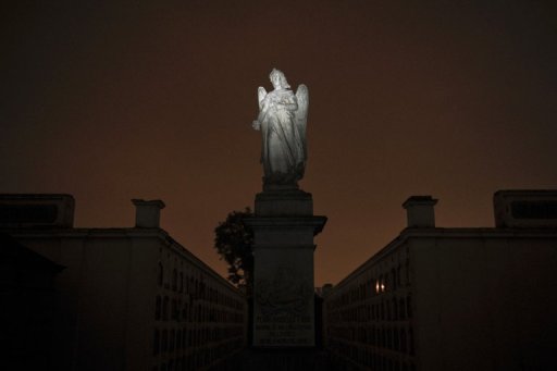
The Presbitero Maestro Cemetery was built between 1805 and 1808 on the former outskirts of Lima and was the first municipal cemetery in Latin America. This impressive and beautiful historical Sanctuary houses the final resting places of many historical important personalities, but is still in use. The neoclassical complex contains the largest collection of 19th century European marble sculptures in Latin America. It’s absolutely worth seeing!

It was cold and dark, and people clutching lanterns in the moonlight gave a spooky cast to Peru's oldest cemetery, now Lima's oddball hit with locals and tourists. "It is scary. But we're into it," said a teenage girl clinging to her boyfriend as they walked through darkness and silence interrupted only by visitors' footsteps.
Each group has a guide who entertain visitors with tales about those buried at the Presbitero Matias Maestro Museum-Cemetery, a Peruvian national historical monument.

The cemetery covers an area of 25,000 m². It has 6 magnificent main gates and over 220,000 people found their final resting place at this outstanding burial ground. Although the Presbitero Maestro Cemetery was declared a National Historic Monument in 1972 the sculptures and the impressive mausoleums are threatened by natural aging, air pollution, pressure of the growing population and unfortunately by vandalism. At least the Public Beneficence Society of Lima tries to preserve this jewel of peace with a very tight budget.

Night tours are scheduled with different themes for different crowds: one focuses on love; another on patriotic fervor; still others on presidents; and inevitably one focuses on death itself. "What really brings in the most people is the tour focused on death, in November, and another on love, in February," says historian Jose Bocanegra, who has the historical details at the ready.

Some visitors are so apprehensive about being in a cemetery that they tiptoe around expecting something worthy of a horror movie. 
When tours started a decade ago they were limited to no more than 40 people; but they have become so popular that groups are now as large as 350 people, mainly young people and tourists, Bocanegra said.

One of the most popular tombs for local visitors is Peruvian poet Jose Santos Chocano, who asked to be buried standing, in a one square meter space. "So his coffin was placed in the niche vertically. And on his tombstone, there are lines from his poem 'Shipwrecked Life,'" Bocanegra said. "This square meter that I have looked for on Earth will be mine, if a bit late. Dead, in the end, I shall have it. ... I only expect now a square meter, where one day they'll have to bury me, standing," the poem reads.

It is a cemetery, and it is dark, to be sure. But there is enough light for visitors to stop and get a look at Carrara marble sculptures like the "La Dama de la Mantilla" (Lady in a mantilla) and "El bastón de Hermes" (Hermes' staff). Bronze works such as "A mother weeping at her son's tomb" and "A cry of pain" also are on display, steeped in the mood of the location, adorning mausoleums that are often caked in mud and apparently forgotten.

The cemetery, tucked into a corner of Lima's Barrios Altos district, was named for its designer, the priest Matias Maestro, who also was buried there. Opened in 1808 by Viceroy Fernando Abascal during Spanish colonial rule, the facility is a sort of history of Peru in tombs and crypts. Decorated with a staggering 940 sculptures -- some of them from as far away as Italy, by sculptors like Santo Varni, Pietro Costa, Ulderico Tenderini, and Rinaldo Rinaldi, or France's Jean Louis Barrias and Antonin Marcie.

The success of the tours is a blessing for the facility, providing a source of funding to care for tombs and sculptures that have themselves often seemed on their last legs.


If you like this post just click here Posted By crkota with No comments

Mysterious African 'Fairy Circles'


In the sandy desert grasslands of Namibia in southern Africa, mysterious bare spots known as "fairy circles" will form and then disappear years later for no reason anyone can determine. A new look at these strange patterns doesn't solve the wistful mystery but at least reveals that the largest of the circles can linger for a lifetime.


When it rains substantially, a thick carpet of grass covers the sand. But this green down is punctuated by bare red soil circular patches, which appear as though drawn by a compass. And there’s not just one or two of them but thousands. These mysterious sand circles appear at around 60 to 120 kilometres inland from the coast from South Africa to Angola, at an altitude of between 500 and 1000 metres. To humans, they make no sense at all. To animals, they’re a source of succulent grass in an arid no man’s land between savannah and sand dunes.

Small fairy circles stick around an average of 24 years, while larger ones can exist as long as 75 years, according to research detailed today (June 27) in the journal PLoS ONE.

Walter Tschinkel may not have solved the mystery of the fairy circles, but he can tell you that they're alive. Tens of thousands of the formations—bare patches of soil, 2 to 12 meters in diameter—freckle grasslands from southern Angola to northern South Africa, their perimeters often marked by a tall fringe of grass. Locals say they're the footprints of the gods. Scientists have thrown their hands up in the air. But now Tschinkel, a biologist at Florida State University in Tallahassee, has discovered something no one else has.
Tschinkel grew interested in fairy circles during a 2005 safari to NamibRand Nature Reserve in southwest Namibia, in the Namib Desert. It was his first experience with the round clearings, tens of thousands of which expose the red sandy soil in the area. A short time after the circles form, a tall ring of grass grows around the border, highlighting the bare area.
By comparing satellite images from 2004 and 2008, Tschinkel found that circles are quite stable, popping up at nearly their full size, or at least growing quickly once they get started. Here, the circles are shown dotting the landscape of Jagkop, Namibia, after a rain.

Few researchers have studied fairy circles, in part because of their remoteness, 111 miles (180 km) from the nearest village, and their work is usually based on opportunistic experiments done on quick trips, Tschinkel says. "There's no program really focused on trying to figure this out."

Over the past 10 years, the park has sold fairy circles to ecotourists for about $50 each. The buyers don't actually get the land; they just adopt it—kind of like people who "purchase" stars. Each circle the reserve sells is marked with the date of sale, and new owners are given the latitude and longitude so they can check up on their purchase on Google Earth.

Did these shallow craters come from space? Are they the work of termites or are they caused by particular mineral compounds in the ground? They’re here in their hundreds of thousands and they’re called “Fairy Circles” -- for want of a better name. And all we know is Namibia’s Fairy Circles are neither a fraud nor a joke, but they’re one of Africa’s most mysterious natural wonders.


If you like this post just click here Posted By crkota with No comments

The Sacred Geometry and Symbols of Washington DC

Symbols are seen as a concept or intention, and also stand-for a referent or extension from anything, from religion to a chemical compound and most importantly, secrete society's. Symbols have been around sense the beginning of time. With out symbols we would have no written language. Numbers are symbols, letters are symbols and they each have their specific meaning. Obvious, right? The thing is, most people don't realize many of the symbols that surround them, nor do they understand their true meaning. Do you ever remember taking a class in high school about symbols? No, of course not, and why? Because if people knew the true meanings of all the symbols that are in the Capitol, the public would be much clearer on the origin's of certain club's and secret society's that control the United States and much of world. Once we start to connect the dots, the truth about secrete society's controlling the United States starts to become very clear and just as obvious as any number or letter. Once you make the conscious effort to recognize the true meaning of the symbols that are laid throughout in the Geometry of Washington D.C. you will be astonished to what you'll find.

The one secret society that seems to have the most influence throughout Washington D.C. are the Freemasons. Now some may say that the Freemasons are not a secret at all and that they have nothing to hide. But on the other hand when out break down the history of masonic symbols, their meanings and the positioning of these symbols throughout the city you'll truly see how influencing these masons really were. So lets take a look at the layout of the roads and the positioning of important sites throughout the city. Just for fun take a map of Washington DC , a pencil, ruler and a compass. You'll be able to map out all sorts of pentagrams, hexagrams, triangles, crosses and even a pentagram (upside-down five pointed star). It's doesn't take a genius to see them, it's quite obvious. So what's the significance? Well for starters many of the Freemason symbols are very heavily influenced by the ancient Egyptians and It's important to understand that Egyptians were heavily influenced by the stars, like how they built the pyramids in perfect alignment with the belt of Orion. It's still unexplained on how the Egyptians were so accurate with their astronomy.


Here we have the great pyramid showing the king and queens chambers along with the holes that go through to the outside in order for certain stars to shine through them at a particular time of the year. What is so fascinating about this is how perfect the angles are through out the entire pyramid and how they relate the are earths Ecliptic plane, Ecliptic Pole, Axis or Celestial Pole and the Equator.


Let's mention the most important angle of all, 23.5 degrees or 23.42 to be precise. This is the angle that our earths axis is tilted at from the Ecliptic Plane. What gives this angle such significance is the fact that the ancient Egyptians knew about this angle of the earths axis at a time when the tools of astronomy were archaic, how they were able to figure it out is still a mystery today.


Now here is a picture that reveals the angles that connect the apex and the two bottom corners to the king and queens chambers and as well the chambers themselves.


Here is a diagram to make these angles a little clearer for you. The angles exist only between five significant points. Gray points out that this is no random occurrence.

The five points are:
1- The Apex
2&3 - The two corners
4&5 - The two chambers
Here we see the angle 23.5 repeated a few times.


As you can see the line between the two base corners (north and south) and the queens chamber is at an angle of 11.75 which times two = 23.5. Then you'll notice that the line from point two being the south corner going the kings chamber in precisely 23.5. Now the question is how do we know they were actually correlating the angles of the pyramid to the earths axis? We can confirm this by looking at a typical diagram of the earth and over lapping the diagrams on top of one-another. Even know that the capstone of the Great Pyramid is missing, we find that it is actually pointing to it's own location on the earth via it's Apex.

How did Osborn come to this conclusion? If you look at the diagram above the king's chamber is at an offset from the Apex by 6.5 degrees. These angles match the geophysical picture of the tilted axis of the earth and the Great Pyramids position on the earth. There for in relation from it being 30 degrees from the equator and as the earth turns it comes as close as 6.5 degrees from the Ecliptic Plane. Now subtract 6.5 from 30 and you get 23.5 degrees.


This diagram here shows the two positions of the Great Pyramid on the earth as the earth turns on a daily bases. As you can see it comes as close as 6.5 degrees and as far as 53.5 from the Ecliptic plane.


OK, so the Great Pyramid is precisely 2,125 meters short of being exactly 30 degrees from the equator. It's exact location is 29.98 degrees which would make the calculations something like one millimeter short of a ten feet to put it in perspective.


This diagram is where it really gets exciting. As you can see when you put the diagram of the Great Pyramid in cross section along with the angles we find that everything lines-up perfectly and that the Great Pyramid is actually pointing to it's own location on earth.


So now the the real question becomes,was this done intentionally or mere coincidence.


Lets move on to Washington DC shall we.


Here we have the layout of DC. See anything interesting? Like all the angles of the roads seeming to correlate with the angles used to create the Great Pyramid. Coincidence? I think not, this was very carefully planned by the Freemasons, but the big question is why?


Here is a diagram of the hidden geometry within the angular dimensions of the great pyramid and you'll notice that the precise angle of the sides of the Great Pyramid are actually 51.84 degrees.


Take that diagram and over lap on a map of Washington DC and you'll see that the streets and buildings match exactly to the same geometric angles of the Great Pyramid.


Now here we have what is called the "tree of life" which depicts the 22 paths or channels that connect the Sephiroth levels or spheres. This "tree of life" was said to originate from Sumeria and is very much like the "sacred tree" that has been seen on early Mesopotamian cylinder seals. The same seals that mention the Annunaki or (the people who came from the sky). This "tree of life" has been depicted in many different forms over the centuries and this picture is a depiction by the Qabbalah.


Take a closer look at the pictures above to see the meanings of each specific placement of each point.


Then of-course we lay the older version of the "tree of life" on top of a map of DC and you'll again find a perfect match along with the angles of the Great Pyramid. We also see that many of the points correspond with major landmarks throughout the city.


Jefferson Monument - Malkuth, otherwise known as "the kingdom" this is the lowest level.
Washington Monument - Yesod, also known as "the foundation"
The White House - Tiphereth, otherwise known as "Beauty" (of the human soul).
The Apex of the tree and the Pyramid - Kether, known as "the father" or "Supreme Crown" and also corresponds with the Hindu "Crown Chaka" this is known as the highest level.
The Apex represents the source center of creation or point zero, and there is nothing on the map of any significance at this location.

Well something that is quite interesting though, is the fact that the "all seeing eye" on the dollar bill as we all know is located just under the capstone of the pyramid and just three blocks east or down from the Apex is the "House of the Temple" which is the headquarters of the supreme council, of the 33 degree Scottish Rite of Freemasonry.


If you notice, the all seeing eye is in correspondence with the headquarters of the supreme council, of the 33 degree Scottish Rite of Freemasonry and recently discovered by Dan Brown (Author of "The De Vinci Code") in his new novel "The Lost Symbol" we find that this is the place of the 33rd -degree "initiation ritual". The 33rd degree is the highest level you can reach within the brotherhood of freemasonry. Maybe it's just shear coincidence, maybe not. Lets look at these next pictures and you can put it together for yourself.


So as we see the angle of 23.5 degrees has great significance and it was the Freemasons that designed the layout of Washington DC.


I personally believe that DC was laid out the way it was in order to create specific energy points throughout the city. Just like the Chakras in the human body. I believe this ancient geometry stems down form the Egyptians who got there knowledge from other beings not of this earth. It would only make sense, who ell's would these people of great power be conspiring for. Think about it, the Capital of the United States has been constructed using sacred ancient Egyptian geometry that came from beings not of this world by the Freemasons who still to this day practice satanic rituals by drinking blood-wine out of a human scull. The evidence is right in front of you, it's just a matter of seeing it.

If you like this post just click here Posted By crkota with No comments

Valley of the Pyramids in the Peru


Peru is rapidly becoming the capital of the pyramid world. Not only does it have the oldest officially recorded pyramid in the world (Caral), with each archaeologist’s spade dig, more pyramid complexes are uncovered.

Purgatorio (purgatory) is the name by which local people refer to the dozens of prehispanic pyramids, enclosures and mounds found on the plain around La Raya Mountain, south of the La Leche River. The Lambayeque Valley boats scores natural and man-made waterways. lt is also a region of numerous pyramids.

It has no less than three pyramid cities, which together have a stunning total of 250 pyramids. The three cities were built in succession of each other, each abandoned before a new one was built.
The first is known as Pampa Grande and was built between 600 and 750 AD. In 700 AD, the pyramid of Pampa Grande, known as Huaca Fortaleza, was built, reaching fifty metres high, and measuring 200 metres in width. Though much of the structure remains intact, visually, it is not all that impressive. The next complex was that of Batan Grande, built between 750 and 1100 AD. The city had 34 pyramids, including the Huaca de Oro (Pyramid of Gold), in front of which a series of royal tombs were located. The pyramids are now badly eroded, due to El Niño rains in 1982 and 1998. But the biggest destruction to the site was man-made when in ca. 1100 AD, the pyramid was burnt and the town abandoned, to be succeeded by Tucume, from 1100 AD until 1500 AD.

The site of Tucume, covering an area of over 540 acres and encompassing 26 major pyramids and platforms, is part of the Lambayeque Valley, the largest valley of the North Coast of Peru. The local shamans still invoke its power and of the gods that once resided in these structures. Specifically, the gods lived in the mountains, but the pyramids were seen as replica mountains, in the hope of being able to work with the forces of nature. The local shamans are also the record keepers of the legends, including one legend recorded by Father Cabello de Balboa in 1586 AD. It relates how Cala, a grandson of Naymlap, the founder of the Lambayeque royal dynasty, declared that Tucume would become the new metropolis for his people. Cala seems to have been an exile from Batan Grande.

Tucume lies on what was once the southern margin of the valley, but thanks to the Taymi irrigation canal (over 43 miles long), which brings water northward from the Chancay river, it is surrounded by fertile agricultural land. lt seems very likely that the construction of the Taymi canal coincided with the foundation of Tucume, an important center of the region throughout its 400-year history. Modern Tucume, which lies very close to the site and boasts its own prehispanic village pyramid, Huaca del Pueblo, is located 17 miles north of the city of Chiclayo.

The largest and most impressive pyramids are found in the monumental sector of the archaeological site, to the north and northeast of La Raya Mountain (“Mountain of the Ray”). Investigations carried out in conjunction with Thor Heyerdahl, the famous Norwegian seafarer and explorer, have concentrated on three major structures: Huaca Larga, Huaca 1 and The U-shaped "Temple of the Sacred Stone". Excavations in non-monumental areas have yielded many details about the functioning of the site -some prefer the term city- and about the lives of its inhabitants.
The "Temple of the Sacred Stone" is a small, unpretentious, rectangular U-shaped structure to the east of Huaca Larga. lt is considered a major temple that travelers had to pass by before entering the site. The walled roadway system of this section of the Lambayeque valley leads straight to this temple and then on to Huaca Larga.
The special, revered object of this temple appears to have been a large, upright boulder in the middle of the one-room building, but whom or what it represented remains unknown. Furthermore, archaeologists found an enormous number of offerings in and around the temple. These offerings included valuable Spondylus shells (a seashell) brought from the coast of Guayaquil, slaughtered lamas and intriguing sheet-metal miniatures representing a wide range of themes and objects (flora, fauna, ornaments, musical instruments, tools, etc.). The most delicate of Inca offerings, figurines made of solid silver or carved Spondylus and adorned with elaborate textiles, silver tupu-needles and miniature feather headdresses, were found deposited in ritual fashion by the doorway of the temple. Researchers have found similar offerings, sometimes together with human sacrifices, at other major Inca shrines. For example, just a few years back a researcher exploring the top of the snow-capped Ampato Mountain in the southern Peruvian department of Arequipa found the intact mummy of an Inca girl, whom he nicknamed "Juanita".

The Túcume area has been slated for tourism development in Peru, however, concerns have been raised over the development of the site without proper attention to conservation. The site's listing in 2004 attracted substantial private-sector support for the site's preservation, but a long-term plan for the conservation of its fragile and eroding remains has yet to be developed.


If you like this post just click here Posted By crkota with No comments
  • Popular
  • Categories
  • Archives