Get widget

News

All kinds of news around the world in one place!

Studies

Explore with us and enjoy in that!

Encyclopedia

Start with us a journey through world of knowledge!

Travel

The world is beautiful. Let's peek into some magnificent places, and see what they offer!

Entertainment

Fun - because we have the right to be happy!

Lifestyle

Our life is adventure. Enjoy in every moment of that!

TOP 10

Amazing lists of incredible things!

Showing posts with label Ancient Buildings. Show all posts

The Baigong Pipes

Do modern metal pipes buried in ancient Chinese stone prove that aliens must have visited?

Should you happen to visit Tibet anytime soon, be sure to stop by the city of Delingha. It's a town of most extraordinary beauty, nestled on the edge of the Qaidam Basin below a range of Himalayan hills. There you'll find the local residents proudly displaying their most famous distinction. For a few yuan you can probably get someone to take you to see it. Only a short journey outside of town is said to be a cave, and in this cave are a series of ancient metal pipes. These pipes predate all known history, and are embedded into the rock itself. They are said to lead through the very mountain, and connect to a nearby salt lake. The explanation? Ruins of a construction project 150,000 years ago, by alien visitors.

The Baigong Pipes are an example of what paranormal enthusiasts refer to as "out of place artifacts", modern objects discovered in ancient surroundings. The Baigong Pipes are described as a sophisticated system of metal pipes, buried in geology in such a way that precludes the possibility of having been installed in modern times. They are located on Mt. Baigong in the Qinghai province of China, about 40 kilometers southwest of Delingha. Most accounts describe a pyramid-shaped outcropping on the mountain, and the cave containing the pipes is on this pyramid. 80 meters from the mouth of this cave is a salt lake (the twin of an adjacent freshwater lake), and more pipes can be found poking up along the shore. Most of the information you can find online about the Baigong Pipes appears to be originally sourced from a 2002 article from the Xinhua News Agency, talking about preparations by a team of scientists about to embark to this remote area to study the pipes. "Nature is harsh here," said one. "There are no residents let alone modern industry in the area, only a few migrant herdsmen to the north of the mountain."

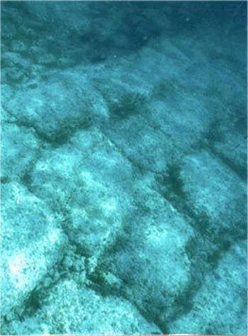
The two lakes are broad, shallow sinks at the low point of the vast Qaidam Basin. Searching for Mt. Baigong is likely to be fruitless: First, the area is largely flat and the nearest mountains are 20 or 30 kilometers away; second, baigong is a local word for hill and could mean anything in this context. The southernmost of the two lakes, Toson Hu or Lake Toson, has some low bluffs here and there along its southern and western sides (Google Maps link), and it is in one of these bluffs (about 50 or 60 meters in height) that author Bai Yu once happened to find what he described as a small cave, according to his book Into the Qaidam.

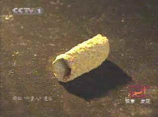
Bai was traveling the area in 1996, and described a lifeless lake surrounded by cone-shaped hills. The cave appeared to have been artificially dug, and was triangular, about six meters deep. Nearby were two similar caves, but they had collapsed and could not be entered. But what struck Bai was the array of manufactured metal pipes protruding up through the floor of the cave and embedded within its walls, one 40 cm wide. Following their path outside, Bai discovered more pipes protruding from the surface of the conical hill, and even more of them 80 meters away from the cave along the shore of the lake. Excited, he removed a sample and sent it to the Ministry of Metallurgical Industry. The result was 92% common minerals and metals, and 8% of unknown composition.

Bai proceeded about 70 kilometers to the Delhi branch of China's Purple Mountain Observatory, a high vantage point from where he knew he could get a birds-eye view of the whole region. He saw great expanses of flat, open terrain, and putting two and two together, he concluded that this would make for a fine alien landing site. Unknown minerals and plentiful landing space meant that the Baigong Pipes had to be of alien origin.

Scientists from the China Seismological Bureau visited the lake in 2001 to examine the pipes. Samples brought back to the Beijing Institute of Geology were examined by thermoluminescence dating, a technique that can determine how long it's been since a crystalline mineral was either heated or exposed to sunlight. The result came back that if these were indeed iron pipes that had been smelted, they were made 140-150,000 years ago. Human history in the region only goes back some 30,000 years, and so the alien theory seemed to have been confirmed. The following year the Xinhua news story was published, and the Baigong Pipes entered pop culture as, supposedly, genuine, tangible evidence of alien visitation.

If you visit the area today, you'll find a locally-built monument to the aliens off the main highway, replete with a mockup metallic satellite dish. Internet forums buzz with the absence of followup articles by Xinhua; the natural conclusion is that it turned out the alien explanation was the true one and the Chinese government is suppressing any further reporting. Cracked.com touts the Baigong Pipes as one of Six Insane Discoveries that Science Can't Explain.

And although that's where most reporting of the Baigong Pipes stops, it's also where responsible inquiry should begin. When you settle on a paranormal explanation, it means you've decided there is no natural explanation. In fact, when you don't yet know the explanation, you don't yet know the explanation; so you can't reasonably decide that the time is right to stop investigating. But so many do.

Skeptical hypotheses have already been put forward, seeking a natural explanation for the Baigong Pipes that doesn't require the introduction of a wild assumption like alien visitation. The first thing we turn to are geological processes that might explain them. The Chinese have put forth several such hypotheses, including one involving the seepage of iron-rich magma into existing fissures in the rock.

A 2003 article in Xinmin Weekly described how this might work. Fractures caused by the uplift of the Qinghai-Tibet plateau could have left the ground riddled with such fissures, into which the highly pressurized magma driving the uplift would have been forced. Assuming this magma was of the right composition that, when combined with the chemical effects of subsequent geological processes, we might very likely expect to see such rusty iron structures in the local rock. But evidence of this has never surfaced, and the Chinese dismissed this theory. They also noted that the Qaidam oil field would not be able to exist if there were active volcanism in the area as recently as 150,000 years ago.

It was their next theory that ultimately led to a satisfactory explanation, and this theory involved the same hypothesized fissures in the sandstone. But, instead of being filled with iron-rich magma, the fissures could have been washed full of iron-rich sediment during floods. Combined with water and the presence of hydrogen sulfide gas, the sediment could have eventually hardened into the rusty metallic pipelike structures of iron pyrite found today. This theory was not fantastic, in part because there was no logical reason why the sandstone might happen to be laced with pipe shaped fissures. But the idea of flooding did make sense, given the geological history of the Qaidam Basin.

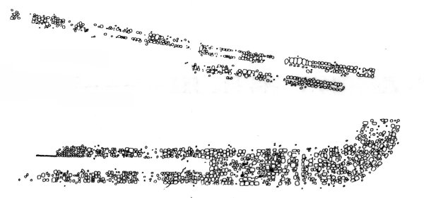
Three years before Bai Yu took his first peek into the cave at Lake Toson, researchers Mossa and Schumacher wrote in the Journal of Sedimentary Research about fossil tree casts in Louisiana. They found cylindrical structures in the soil, thermoluminescence dated from 75-95,000 years ago. The chemical composition of the cylinders varied depending on where and when they formed and in what type of soil. The authors found that these were the fossilized casts of tree roots, formed by pedogenesis (the process by which soil is created) and diagenesis (the lithification of soil into rock through compaction and cementation). The result of this process was to create metallic pipelike structures, which by comparing the descriptions offered by researchers, appear to be a perfect match for the Baigong Pipes.

The Chinese scientists eventually did come to the same conclusion, according to the Xinmin Weekly article. They used atomic emission spectroscopy to conduct a detailed chemical analysis of the rusty pipe fragments, and found them to contain organic plant matter. Under the microscope they found tree rings, consistently throughout the samples. Once they established that the Baigong Pipes were simply fossilized tree casts, they set about to discover how they got there.

The Qaidam basin was once a vast lake, which has disappeared as the Qinghai-Tibet plateau uplifted the basin to its current elevation of about 2800 meters. Over the millennia, various floods filled the sink with runoff, alluvium, and debris including such fossils. They can now be found wherever such ancient flows deposited them, and it seems that Bai Yu was lucky enough to discover just such a pocket.

And so we end up with a complete story of how rusty iron pipes, tens of thousands of years older than any people who might have forged them, can end up embedded in solid sandstone in such a way as to baffle the average observer. Like many amateur researchers, Bai Yu stumbled upon an extraordinary discovery, but through his lack of applicable knowledge, misinterpreted what he saw. Those who underestimate the Earth's ability to produce fascinating effects are often left to grope for goofy explanations like alien construction projects. I find that the Baigong Pipes are one of the better examples of the folly of stopping at the paranormal explanation, compared to the rich rewards offered by following the scientific method to uncover what's really going on.

If you like this post just click here Posted By crkota with 1 comment

The ancient Rosslyn Chapel

The ancient Rosslyn Chapel, beloved as the key to mysteries surrounding The Da Vinci Code, the Holy Grail and the Knights Templar, has thrown up another unfathomable puzzle: what lies behind the secret of the bees?

Builders renovating the 600-year-old chapel have discovered two beehives carved within the stonework high on the pinnacles of the roof. They are thought to be the first man-made stone hives ever found.

It appears the hives were carved into the roof when the chapel was built, with the entrance for the bees formed, appropriately, through the centre of an intricately carved stone flower. The hives were found when builders were dismantling and rebuilding the pinnacles for the first time in centuries.

Malcolm Mitchell, from Page Park, the architects on the £7 million restoration, said it appeared the chapel had been a haven for the insects as long ago as the 15th century.

“From the research that we have done, this is a unique situation in Europe. We haven’t found any precedent of this type of hive before. We were quite taken aback. It’s very unusual.

“In Scotland, hives are so often made of baskets which can be lifted and moved around. It was particularly a surprise because the hives themselves are the ideal size for bees to inhabit — hollowed out to the size of a gas cylinder — but they were constructed purely as a haven for the bees. They weren’t built to harvest honey,” he added.

“It was just out of kindness and respect to the sacredness of these insects. Reverence to bees insects goes back historically to Egyptian times.”

Although human beings have collected honey from wild bee colonies since time immemorial, at some point they began to domesticate wild bees in artificial hives, made from hollow logs, pottery, or woven straw baskets. The Egyptians kept bees in cylindrical hives, and pictures in temples show workers blowing smoke into the hives, and removing honeycombs. Sealed pots of honey were found in Tutankhamun’s tomb.

Bronze Age hives made of straw and unbaked clay have been dug up near Jerusalem. They were found in orderly rows, three high, each one accommodating around 100 hives. The Greeks also developed bee-keeping as an art, and celebrated it on gold rings and ornaments.

Honeycombs were found abandoned inside the hive in the north pinnacle, but, equally strangely, the hive on the south pinnacle did not have an entry hole for bees and therefore had not been occupied.

Mr Mitchell said: “It’s just another of Rosslyn’s mysteries. The north pinnacle was full of honeycombs which had been abandoned for some considerable years. The honey had all dried up.”

The experts believe the interior of the hives were lined with a coating to prevent the wild bees from gnawing away at the stonework.

Allan Gilmour, from Hunter & Clark stonemasons, the main contractors on the chapel, said: “I’ve never heard of man-made stone beehives. What I have seen is bees creating hives in stone. When we restored the Irvine Town House we found that bees had burrowed into the sandstone and created honeycombs. They had weakened the stone.

“Maybe at Rosslyn the monks had the same problem in the past and created the hive as a sanctuary.”

There is anecdotal evidence that visitors to the chapel, which dates back to 1446, used to be disturbed by bees. Mr Mitchell said some of the staff at the Rosslyn Trust were aware some years ago that there had been bees going into the cavity. The hives have now been reinstated within the rebuilt pinnacles on the roof of the chapel.

Rosslyn Chapel was built on the orders of William St Clair, Prince of Orkney. Begun in 1446. work ceased in 1484 when William died, so that the building was then in the form it remains in today.

Members of the Scottish Beekeepers’ Association said yesterday they had not heard of beehives created from stone. Mrs Una Robertson, the organisation’s historian, said: “I’m not an architect, but it’s the sort of thing that might have come my way. Bees do go into roof spaces and set up home, and can stay there a long time, but it’s unusual to want to attract bees into a building.

“Traditonally, bees were kept in a skep — made out of straw or dried grass. Skeps have been around for centuries. Wooden hives only came in since the 17th century. Bees have been kept in all sorts of containers , but I have never heard of stone.”

If you like this post just click here Posted By crkota with 1 comment

A Host of Mummies, a Forest of Secrets

In the middle of a terrifying desert north of Tibet, Chinese archaeologists have excavated an extraordinary cemetery. Its inhabitants died almost 4,000 years ago, yet their bodies have been well preserved by the dry air.

The cemetery lies in what is now China’s northwest autonomous region of Xinjiang, yet the people have European features, with brown hair and long noses. Their remains, though lying in one of the world’s largest deserts, are buried in upside-down boats. And where tombstones might stand, declaring pious hope for some god’s mercy in the afterlife, their cemetery sports instead a vigorous forest of phallic symbols, signaling an intense interest in the pleasures or utility of procreation.

The long-vanished people have no name, because their origin and identity are still unknown. But many clues are now emerging about their ancestry, their way of life and even the language they spoke.

Their graveyard, known as Small River Cemetery No. 5, lies near a dried-up riverbed in the Tarim Basin, a region encircled by forbidding mountain ranges. Most of the basin is occupied by the Taklimakan Desert, a wilderness so inhospitable that later travelers along the Silk Road would edge along its northern or southern borders.

In modern times the region has been occupied by Turkish-speaking Uighurs, joined in the last 50 years by Han settlers from China. Ethnic tensions have recently arisen between the two groups, with riots in Urumqi, the capital of Xinjiang. A large number of ancient mummies, really desiccated corpses, have emerged from the sands, only to become pawns between the Uighurs and the Han.

The 200 or so mummies have a distinctively Western appearance, and the Uighurs, even though they did not arrive in the region until the 10th century, have cited them to claim that the autonomous region was always theirs. Some of the mummies, including a well-preserved woman known as the Beauty of Loulan, were analyzed by Li Jin, a well-known geneticist at Fudan University, who said in 2007 that their DNA contained markers indicating an East Asian and even South Asian origin.

The mummies in the Small River Cemetery are, so far, the oldest discovered in the Tarim Basin. Carbon tests done at Beijing University show that the oldest part dates to 3,980 years ago. A team of Chinese geneticists has analyzed the mummies’ DNA.

Despite the political tensions over the mummies’ origin, the Chinese said in a report published last month in the journal BMC Biology that the people were of mixed ancestry, having both European and some Siberian genetic markers, and probably came from outside China. The team was led by Hui Zhou of Jilin University in Changchun, with Dr. Jin as a co-author.

All the men who were analyzed had a Y chromosome that is now mostly found in Eastern Europe, Central Asia and Siberia, but rarely in China. The mitochondrial DNA, which passes down the female line, consisted of a lineage from Siberia and two that are common in Europe. Since both the Y chromosome and the mitochondrial DNA lineages are ancient, Dr. Zhou and his team conclude the European and Siberian populations probably intermarried before entering the Tarim Basin some 4,000 years ago.

The Small River Cemetery was rediscovered in 1934 by the Swedish archaeologist Folke Bergman and then forgotten for 66 years until relocated through GPS navigation by a Chinese expedition. Archaeologists began excavating it from 2003 to 2005. Their reports have been translated and summarized by Victor H. Mair, a professor of Chinese at the University of Pennsylvania and an expert in the prehistory of the Tarim Basin.

As the Chinese archaeologists dug through the five layers of burials, Dr. Mair recounted, they came across almost 200 poles, each 13 feet tall. Many had flat blades, painted black and red, like the oars from some great galley that had foundered beneath the waves of sand.

At the foot of each pole there were indeed boats, laid upside down and covered with cowhide. The bodies inside the boats were still wearing the clothes they had been buried in. They had felt caps with feathers tucked in the brim, uncannily resembling Tyrolean mountain hats. They wore large woolen capes with tassels and leather boots. A Bronze Age salesclerk from Victoria’s Secret seems to have supplied the clothes beneath — barely adequate woolen loin cloths for the men, and skirts made of string strands for the women.

Within each boat coffin were grave goods, including beautifully woven grass baskets, skillfully carved masks and bundles of ephedra, an herb that may have been used in rituals or as a medicine.

In the women’s coffins, the Chinese archaeologists encountered one or more life-size wooden phalluses laid on the body or by its side. Looking again at the shaping of the 13-foot poles that rise from the prow of each woman’s boat, the archaeologists concluded that the poles were in fact gigantic phallic symbols.

The men’s boats, on the other hand, all lay beneath the poles with bladelike tops. These were not the oars they had seemed at first sight, the Chinese archaeologists concluded, but rather symbolic vulvas that matched the opposite sex symbols above the women’s boats. “The whole of the cemetery was blanketed with blatant sexual symbolism,” Dr. Mair wrote. In his view, the “obsession with procreation” reflected the importance the community attached to fertility.

Arthur Wolf, an anthropologist at Stanford University and an expert on fertility in East Asia, said that the poles perhaps mark social status, a common theme of tombs and grave goods. “It seems that what most people want to take with them is their status, if it is anything to brag about,” he said.

Dr. Mair said the Chinese archaeologists’ interpretation of the poles as phallic symbols was “a believable analysis.” The buried people’s evident veneration of procreation could mean they were interested in both the pleasure of sex and its utility, given that it is difficult to separate the two. But they seem to have had particular respect for fertility, Dr. Mair said, because several women were buried in double-layered coffins with special grave goods.

Living in harsh surroundings, “infant mortality must have been high, so the need for procreation, particularly in light of their isolated situation, would have been great,” Dr. Mair said. Another possible risk to fertility could have arisen if the population had become in-bred. “Those women who were able to produce and rear children to adulthood would have been particularly revered,” Dr. Mair said.

Several items in the Small River Cemetery burials resemble artifacts or customs familiar in Europe, Dr. Mair noted. Boat burials were common among the Vikings. String skirts and phallic symbols have been found in Bronze Age burials of Northern Europe.

There are no known settlements near the cemetery, so the people probably lived elsewhere and reached the cemetery by boat. No woodworking tools have been found at the site, supporting the idea that the poles were carved off site.

The Tarim Basin was already quite dry when the Small River people entered it 4,000 years ago. They probably lived at the edge of survival until the lakes and rivers on which they depended finally dried up around A.D. 400. Burials with felt hats and woven baskets were common in the region until some 2,000 years ago.

The language spoken by the people of the Small River Cemetery is unknown, but Dr. Mair believes it could have been Tokharian, an ancient member of the Indo-European family of languages. Manuscripts written in Tokharian have been discovered in the Tarim Basin, where the language was spoken from about A.D. 500 to 900. Despite its presence in the east, Tokharian seems more closely related to the “centum” languages of Europe than to the “satem” languages of India and Iran. The division is based on the words for hundred in Latin (centum) and in Sanskrit (satam).

The Small River Cemetery people lived more than 2,000 years before the earliest evidence for Tokharian, but there is “a clear continuity of culture,” Dr. Mair said, in the form of people being buried with felt hats, a tradition that continued until the first few centuries A.D.

An exhibition of the Tarim Basin mummies opens March 27 at the Bowers Museum in Santa Ana, Calif. — the first time that the mummies will be seen outside Asia.

If you like this post just click here Posted By crkota with No comments

The Wicker Man

The Wicker Man is set on fire to pay tribute to the gods. The sacrifice of the humans inside is part of a religious ritual to increase fertility, crops, commerce, or merely to re-ignite the chances that bad times will disappear.

According to Julius Caesar in his Commentarii de Bello Gallico (Commentary on the Gallic Wars), the Wicker Man was a large wicker statue of a human used by the ancient Druids (priests of Celtic paganism) for human sacrifice by burning it in effigy. Other records talk of people being placed inside.

Despite any debunking of Caesar's accounts by modern skeptics, the imagery of the burning of the Wicker Man lives on and its use cannot be denied in modern neo-pagan rituals. Whether the Wicker Man exists in historic Pagan accounts, in modern neo-Pagan events (such as at Nevada's Burning Man), or in movies and contemporary events, the symbolism is very real and powerful.

And quite obvious.

For those interested in deciphering the unfolding of the sacrifices (including murder-suicides and costumed violence of late) during these difficult times, please pay attention to these signs, noticed already by those to whom the twilight language is being directed.

As I already have mentioned in these pages, it goes beyond coincidence to find the moniker of the Wicker turning up during incidents from the Son of Sam killings to last year's Chicago area "Phantom Clown" sightings and near-abductions of children. Keep your eyes open.


From an article published this morning, comes news of this celebration:

A 12-foot tall Wicker Man will be set on fire tonight [Friday, January 30, 2009] in a pagan winter ritual close to the Fermanagh border [Northern Ireland].

[The name Fermanagh is an Anglicization of Fhear Manach which means "Men of the Manacháin tribe," so named after their chief O'Manacháin (Anglicized as O'Monaghan), the famous warrior monk. Contae Fhear Manach or Fear Manach = "Men of Monach" in Irish.]

The folk ceremony at Aughakillymaude Mummers Centre near Derrylin will celebrate the loosening of winter’s grip and the impending return of spring as it marks February 1, known as a Quarter Day in the Celtic agricultural calendar.

At 10 pm [local time] the straw mummers hats worn all winter by the troupe performing their traditional drama will be set on fire to mark the close of the mumming season and the Wicker Man will then be lit.

The huge figure has been created by model maker Gordon Johnston from flexible sally rods — willow rods used for wicker furniture and fencing. According to Jim Ledwith of the Mummers Foundation, little is known about the origins of the Wicker Man, apart from Julius Caesar’s second hand accounts of druidic winter rituals of human sacrifice during the Gallic wars.

These alleged that female slaves and criminals were burned alive inside effigies 100 times the size of the Fermanagh one.

“While the details of the wicker man ritual may have become coloured with the telling, it represents a tradition of sacrifice by burning practiced by the continental Celts.

“Indeed, the practice of human sacrifice was still prevalent in fifth and sixth century Ireland,” Jim said.

“Throughout Celtic Europe the wicker man legend lives on and the effigy is still burned ceremoniously as a mock sacrifice in themed ceremonies, especially at Beltaine (May) to mark the rite of spring — notably without the human sacrifice element.”

Mummers will light a gas beacon at Aughakillymaude to symbolise the sun’s return.

The 1973 movie The Wicker Man, starring Edward Woodward and Christopher Lee, is regarded as one of the finest horror films of all time, and it ends with Woodward, playing a police detective, being burned alive inside the chest of the effigy.

Don't Look Now an Anglo-Italian thriller, directed by Nicolas Roeg, was released in 1973. In the double-billing that took place back then, 1973's The Wicker Man was the "A" feature on their original UK theatrical dual release.

The figure of the "little person" in the red rain gear in Don't Look Now serves as a trigger or key. As Wikipedia notes, the "spiraling vortex of coincidences, recurring themes and motifs (light on water, breaking glass, the colour red)...reaches a dramatic conclusion in an old bell tower. John [Baxter, the lead character, played by Donald Sutherland] confronts the mysterious figure in red, realizing too late that his visions were premonitions of a grisly end."

A less well-remembered American remake of The Wicker Man, with Nicolas Cage in the lead, was released in 2006 with the film's tale being set on a private island in Puget Sound, Washington. In this 2006 version, a little girl is seen running around in a red coat. As well, there is a pair of twins, old women, both of whom are blind.

In the feature film Flatliners, Kiefer Sutherland is tormented by a small childlike figure in a red hooded coat in an homage to his father's film.

The theme of the little red-clad Venetian figure is used in a dream sequence in the "Book Clubbin'" episode of television series "Absolutely Fabulous," Series 5.

The Irish feature film Intermission (starring Colm Meaney and Colin Farrell) references Don't Look Now's chase of a small figure in a red coat several times.

Don't Look Now's drowning scene is referenced by the 2005 film The Dark starring Sean Bean and Maria Bello in which their daughter drowns wearing a bright red sweater.

In the 2005 film Hostel, a figure fleetingly glimpsed wearing a red raincoat is pursued through narrow alleyways.

The end chase scene of Don't Look Now is referenced in the 2006 release of Casino Royale where James Bond is pursuing Vesper through Venice while she is wearing a red coat.

The Wicker Man burns red.

If you like this post just click here Posted By crkota with No comments

Caribbean Underwater Pyramids

One of the most intriguing tales of the discovery of ruins of a lost civilization is the story of Dr. Ray Brown. In 1970, while diving near the Bari Islands in the Bahamas, Dr. Brown claimed to have come across a pyramid "shining like a mirror" that he estimated was 120 feet tall, although he could see only the top 90 feet. The pyramid had a colored capstone and was surrounded by the ruins of other buildings. Swimming into a chamber he found a crystal held by two metallic hands. Over the crystal hung a brass rod from the center of the ceiling, at the end of which was a red multifaceted gem of some kind. Brown said he took the crystal, which allegedly has strange, mystical powers.
Brown's story sounds fictitious - it's just too spectacular. But it excites the imagination and wonder about all the mysteries that could be down there - lost worlds awaiting rediscovery.


A 'lost city', that could turn out to be the fabled city of Atlantis, has been located by a Canadian scientific research team. In a press release dated Havana, 14 May 2001 Reuters of London informed the world that Soviet-born ocean engineer Paulina Zelitsky, the president of Canadian-based company Advanced Digital Communications, had detected 'a sunken city' in deep waters off the west coast of Cuba, the largest island of the Caribbean. Satellite-integrated ocean bottom positioning systems, echo sounders and high precision side-scan double-frequency sonar have detected the presence of what are being described as 'shapes' that 'resemble pyramids, roads and buildings'. Their regularity seems consistent with the idea that they represent an 'urban development' composed of 'symmetrical architecture'. Reuters reported that the deep-sea city is located on a huge land plateau lying in around 2,200 feet (700 metres) of water. Furthermore, that in Paulina's opinion the complex belongs to 'the pre-classic period' of Central American history, and was populated by 'an advanced civilization similar to the early Teotihuacán culture of Yucatán'. 'It is stunning,' she said during an interview with the Reuters representative at her office at Tarara, on the coast east of Havana. 'What we see in our high-resolution sonar images are limitless, rolling, white sand plains and, in the middle of this beautiful white sand, there are clear man-made large-size architectural designs. It looks like when you fly over an urban development in a plane and you see highways, tunnels and buildings. 'We don't know what it is, and we don't have the videotaped evidence of this yet, but we do not believe that nature is capable of producing planned symmetrical architecture, unless it is a miracle,' she added. Paulina is cautious about what lies beneath the glistening blue waters of the Yucatán Channel, admitting only that she is 'excited but reluctant to speculate until a joint investigation with the Cuban Academy of Sciences and the National Geographic Society takes place early this summer.' The discoveries were made last summer during deep-sea surveys made by Paulina and a trained scientific research team aboard the Cuban research vessel Ulises. Sonar images revealed 'an extensive series of structures' over a several-mile area in darker and lighter shades. The site is close to the edge of the underwater geological feature known as the Cuban shelf, which falls off sharply in a series of shelves which drop down to several thousand metres, and it is on one of these shelves, in around 600-700 metres of water, that the structures are to be found. The mass of rectilinear features are said to be located in the proximity of an 'extinct volcano, geological faults and a river bed'. This last fact alone shows that the land shelf, which rises to a height of around 40 metres, was once above water. 'Whenever you find a volcano, there is often a settlement associated with it,' Paul Weinzweig, Paulina's husband and a director of ADC, observed. 'I don't know the exact relationship, but it is in the same vicinity as the volcano, the fault lines and the river. They're quite close to one another.' On the matter of whether the sonar imagery really does show 'pyramids, roads and buildings', Paul stated: 'We had been looking at the images for some months, and keep a picture on the wall showing pyramids in the Yucatán, and let's just say they kept reminding us of these structures. They really do look like an urban development.' As to whether the light and dark areas of the sonar imagery appear to be three-dimensional features or not, he answered: 'There's a lot of symmetry, apart from actual shapes, and some suggestion of structure. Some American geologists have looked at them and said that the darker shadings are suggestive of metal roofing.' In order to explore the site more closely, ADC are currently planning to send down remote robot video cameras and a one-man submersible. We therefore look forward to further news of these discoveries in the coming months.

The Search for Sunken Vessels

ADC's intentions had never been to search for sunken cities. Their scientific operation to survey the deep waters off the Cuban coastline forms part of a joint venture set up between the Canadian company and the Cuban government, in particular its state partner Geomar. One of their principal aims is the location of the billions of dollars of bullion and lost treasure disgorged from sunken ships since the time of the Conquest. As Paul said: 'Cuba has the richest galleon cemetery in the world.' Over the past 500 years it is estimated that hundreds, if not thousands, of vessels must have been lost in Cuban waters due poor navigation, piracy on the high seas and the violent Caribbean storms that plague the region on a frighteningly regular basis. Visa Gold, a Toronto-based low-tech company which operates out of Havana's Marina Hemingway, claims already to have found some 7,000 objects from sunken vessels. They include jewellery, diamonds and pistols, said to have come from a brigantine called Palemon, lost off Cuba's northern coast in 1839. Visa Gold's next target is the Atocha y San Jose, a Spanish vessel. It sank in Havana Bay in January 1642 after fleeing storms at sea. The renewed interest in treasure salving in Cuban coastal waters comes in the wake of Fidel Castro's government recognising the fact that it does not have the ocean expertise or the inclination to conduct scientific operations of this nature. Its divers, who are considered to be among the best in the world, have been diving off Cuba's coast treasure hunting for decades. Yet Cuba lacks expertise and technology for deep-ocean search and science, which is why they have invited ADC to take up the challenge. Their 80-metre oceanographic reseach vessel, the Ulises, uses high-tech equipment and a highly trained scientific team to survey the ocean bottom up to a depth of several thousand metres. It was their high-skilled sonar software analysts who detected the reported underwater remains in the Yucatán Channel. 'These projects are very important in helping us rescue things from history, which contribute to our national patrimony,' said Eddy Fernandez, vice president of Geomar. 'As you know, we have financing problems. This is a very expensive activity. They give us technology and financing. We provide historical and ocean expertise'.

THE CUBA-ATLANTIS ARGUMENT

The implications of ADC's discoveries off Cuba's western coastline are far reaching and quite extraordinary. In an on-line pole, conducted by the NBC home news service MSNBC, of the 1827 people who had voted by the end of 26 May 2001, no less than 73 percent believed that the find 'could be something big: Next stop, Atlantis'. It means that already NBC are considering the possibility that the sunken city could be linked with Plato's account of the lost city of Atlantis. This is good news for me, as my book GATEWAY TO ATLANTIS, published in 2000, concluded that the most likely location of Plato's sunken empire was Cuba, the first time that this country had ever been proposed in this respect. I pointed out that the evidence contained in Plato's works the TIMAEUS and CRITIAS hinted strongly that his view of Atlantis was based on stories and rumours reaching the ancient world via Phoenician and Carthaginian who were crossing the Atlantic prior to his age. Moreover, Plato's description of Atlantis' great plain, said to have been 3000 by 2000 stadia (552 by 368 kilometres) in size, matches very well Cuba's great western plain. Before the rapid rise in sea-level following the end of the last Ice Age this stretched southwards across the Bay of Batabanó to the mysterious Isle of Youth and was originally 540 by 160 kilometres in size. Although I speculated in the book - which has now been published in the USA, Italy, Holland, Germany and Portugal - that the Atlantean city might await discovery beneath the shallow waters of the Bay of Batabanó, news that a sunken city may now have been detected in the Yucatán Channel, between Cuba and the Yucatán peninsular, is exciting news. Incidentally, ADC have plans to explore the Bay of Batabanó during the next year, so it should be interesting to see what if anything they find here.

The Search for the Mother Lode

In September 1972 American oceanic explorer J. Manson Valentine, flying over the Bahamas in a light aircraft with and his associate Jim Richardson, noticed a mass of rectilinear and curvilinear features in shallow waters on the south-western edge of the former Bahaman landmass (now the Great Bahama Bank). Valentine referred to this mass of possible archaeological features as 'the mother lode'. They faced out across the Old Bahama Channel, like some kind of ancient port serving the Cuban mainland. As early as the 1950s light-aircraft pilots reported seeing what they described as underwater 'stonework' which was 'well within Cuban waters'. Similar sightings 'north of Cuba' of an alleged 'submerged building complex covering over ten acres' might even have convinced the Cuban government that a veritable city awaited discovery in its vigorously defended waters. There are, for instance, unconfirmed reports that this 'building complex' was explored with the assistance of Soviet submarines based in Cuba during the 1960s. Strange then that these recent discoveries of a sunken city in Cuban waters are being conducted by a Russian-born Canadian oceanographer. Among those who felt they had glimpsed the remains of a lost citadel in Cuban waters was Leicester Hemingway, brother of the writer Ernest Hemingway. During a flight into the country, Leicester noticed, beyond its northern coast, 'an expanse of stone ruins, several acres in area and apparently white, as if they were marble'. The exact location of these underwater features remains unclear. Only time will tell whether the discoveries made by Paulina Zelitsky and ADC do constitute firm evidence of Plato's Atlantis, for if they do then it will fix, once and for all, its geographical location in the Bahamas and Caribbean, and not anywhere else in the world. However, the location of a lost city on a huge land plateau lying at a depth of around 600-700 metres poses new problems for the Atlantis debate. Plato wrote that his Atlantic island empire was destroyed by 'earthquakes and floods' in 'one terrible day and night', post-8570 BC in the TIMAEUS and around 9421 BC in the CRITIAS. This time-frame corresponds with the cessation of the last Ice Age, when we know that the sea-levels began to rise fairly rapidly as the ice fields which had covered vast areas of North America and Europe for tens of thousands of years began to disappear. In GATEWAY TO ATLANTIS I proposed that the mechanism behind Atlantis' destruction was a comet impact which devastated the eastern Atlantic coast of America, causing literally 500,000 elliptical craters, known today as the Carolina Bays, sometime around 8500 BC (+/- 500 years). Fragments of the comet falling in the Western Atlantic basin, north of the Bahamas, would have created tsunami tidal-waves perhaps hundreds of metres high. These would have drowned, temporarily at least, large parts of the Bahamas and Caribbean, as well as many low-lying regions of the eastern United States. Myths and legends told by the indigenous peoples of the Bahaman and Caribbean archipelagos, when the Spanish first reached the New World, spoke of just such a cataclysm. They said that the waters suddenly rushed in and drowned the great landmass, breaking it up into the individual islands seen today. Although a fragmentation of the former landmasses of the Bahamas and Caribbean in the manner indicated could not have been caused by tsunamis alone, the gradual rise in the sea-level which followed this cataclysmic event would have drowned, more permanently this time, all low-lying regions, creating the archipelagos we see today. Yet in the thousands of years which it took for the ice fields to melt in full, the sea-level rose only 300 metres (some estimates place it as much as 400 metres). If the 'city' does lie in 600-700 metres of water, we will need to propose a suitable geological mechanism in order to justify its submergence to this depth post 9000 BC. Either that, or we will have to define a geological time-frame in which the land plateau, with its volcano, fault lines and river was above sea-level. Paulina's statement that the 'city' might belong to 'the pre-classic period' of Mesoamerican history, and was populated 'by an advanced civilisation similar to the early Teotihuacán culture of Yucatán', is very difficult to equate with the discovery. The Teotihuacán culture, which thrived in Central Mexico from around 400 BC through until around AD 500, remains an enigma to archaeologists. Its origin is unclear. What we do know is that legends once told by the Totonac peoples of eastern Mexico spoke of the founders of its sacred city of Teotihuacán, with its mighty Pyramids of the Sun and Moon, as having arrived on the Gulf coast from an island homeland which lay beyond the sea. Here was to be found Chicomoztoc, the Seven Caves, where the first humans emerged out of the darkness at the beginning of time. For many reasons, not least of all the appearance of sea-shells of a purely Caribbean nature carved on the walls of the Temple of Quetzalcoatl at Teotihuacán, the Teotihuacán culture saw their ancestral homeland as connected in some way with the Caribbean. Moreover, in GATEWAY TO ATLANTIS I identified the original Seven Caves complex as the Punta del Esté caves on Cuba's Isle of Youth, one of which, Ceuva # 1, has been described as a veritable Sistine Chapel of the prehistoric world. Many thousands of years ago unknown artists adorned its walls and ceilings with abstract petroglyphs of a blatantly celestial nature. Yet even so, any sunken city lying off the northern coast of Cuba, in 600-700 metres of water, must antedate the Teotihuacán culture by many thousands of years. Curiously, Pauline Zelitsky visited Ceuva # 1 at the Punta del Esté complex during the summer of 2000, shortly before she made her dramatic discovery of the underwater 'city'. There is something magical about this place. It assaults the senses and inspires thoughts regarding the origins of Cuba's indigenous peoples and their apparent knowledge of the cataclysm which devastated the region so many thousands of years ago. If Paulina Zelitsky and her oceanographic colleagues are right in their belief that 'pyramids, roads and buildings' do lie off Cuba's western coastline, then it is clear that the prehistory of the Caribbean, and its influence on the rise of Mesoamerican civilisation, will have to be revised dramatically. Moreover, it could well be that at long last the mystery of Atlantis, mankind's greatest historical enigma, is about to unfold in a most spectacular fashion. Sources: 'Looking for lost riches in Cuba's seas: Underwater surveyors say they may have found sunken city', Reuters report dated Havana, 14 May, 2001, Collins, Andrew, GATEWAY TO ATLANTIS, Headline, London, 2000; Carroll & Graf, USA, 2000.


If you like this post just click here Posted By crkota with No comments

The Secrets of Coral Castle

Did a Latvian immigrant rediscover the secrets to the building of the pyramids... of levitation... of anti-gravity? His amazing "castle" may hold clues to long-lost powers.

Coral Castle in Homestead, Florida, is one of the most amazing structures ever built. In terms of accomplishment, it's been compared to Stonehenge, ancient Greek temples, and even the great pyramids of Egypt. It is amazing - some even say miraculous - because it was quarried, fashioned, transported, and constructed by one man: Edward Leedskalnin, a 5-ft. tall, 100-lb. Latvian immigrant.

Many men have single-handedly built their own homes, but Leedskalnin's choice of building materials is what makes his undertaking so incredible. He used huge blocks of coral rock, some weighing as much as 30 tons, and somehow was able to move them and set them in place without assistance or the use of modern machinery. And therein lies the mystery. How did he do it?

It's estimated that 1,000 tons of coral rock were used in construction of the walls and towers, and an additional 100 tons of it were carved into furniture and art objects:
  • An obelisk he raised weighs 28 tons.
  • The wall surrounding Coral Castle stands 8 ft. tall and consists of large blocks each weighing several tons.
  • Large stone crescents are perched atop 20-ft.-high walls.
  • A 9-ton swinging gate that moves at the touch of a finger guards the eastern wall.
  • The largest rock on the property weighs an estimated 35 tons.
  • Some stones are twice the weight of the largest blocks in the Great Pyramid at Giza.

Working alone, Leedskalnin labored for 20 years - from 1920 to 1940 - to build the home he originally called "Rock Gate Park" in Florida City. The story goes that he built it after being jilted by his fiancée, who changed her mind about marrying him because he was too old and too poor. After wandering around the U.S. and Canada for several years, Leedskalnin settled in Florida City for health reasons; he had been diagnosed with tuberculosis. He began building his coral home in 1920. Then in 1936, when a planned new subdivision of homes threatened his privacy, Leedskalnin moved his entire home 10 miles to Homestead, where he completed it, and where it still stands as a tourist attraction.

How Leedskalnin managed this feat of engineering has remained a mystery all these years because, incredibly, no one saw him do it. A secretive man, Leedskalnin often worked at night by lantern light. And so there are no credible witnesses to how the small, frail man was able to move the huge blocks of rock. Even when he moved the entire structure to Homestead, neighbors saw the coral blocks being transported on a borrowed truck, but no one seems to know how Leedskalnin got them on and off the vehicle.

Lots of weird stories have been told and bizarre theories proposed to explain Coral Castle. And since no witness can dispute any of them, they are all worthy of consideration.


The Theories

  • One story says that some curious neighbors did see how Leedskalnin moved the stones. They say he placed his hands on the stone to be lifted... and sang. Somehow this levitated the great rocks.
  • According to an article in Fate magazine, "some teenagers spying on him one evening claimed they saw him 'float coral blocks through the air like hydrogen balloons,' but no one took them seriously."
  • Frank Joseph, in the Fate magazine article, also writes, "Alternative science investigators suggest that Leedskalnin somehow learned the secret of the 'world grid,' an invisible pattern of energy lines surrounding the Earth which concentrates points of telluric power where they intersect. It was here, at one of these intersections of Earth energy, that he was supposedly able to move his prodigious stone blocks using the unseen power of our planet." Yet that still does no explain how Leedskalnin was able to tap this power, and others cannot.
  • Coral Castle quotes J. Cathie, a captain flying with National Airways Corp. of New Zealand, as saying: "Measurements from the Coral Castle position to the zero-degree and 90-degree longitude lines, when they passed through the equator, also yielded harmonics related to light and gravity. The final check of the distance between Coral Castle and grid pole A in the north, dispelled any doubt about the site being in an ideal position to allow Leedskalnin to erect the huge blocks of coral with relative ease. Measurements from all major points gave the geometric harmonics necessary for the manipulation of anti-gravity." Cathie also believes that this energy grid is also responsible for many UFO sightings.
  • In an article by called "The Coral Castle Mystery" in Atlantis Rising, author Christopher Dunn asserts: "What if there's no such thing as gravity? And the natural forces we already know about are sufficient to explain the noted phenomena we have labeled as gravity? Perhaps Leedskalnin's means of working with the Earth's gravitational pull was nothing more complicated than devising a means by which the alignment of magnetic elements within his coral blocks was adjusted to face the streams of individual magnets he claims are issuing forth from the Earth with a like repelling pole."
  • When he was personally asked how he managed the feat, Leedskalnin replied only that he understood the laws of weight and leverage. He is quoted as saying, "I have discovered the secrets of the pyramids. I have found out how the Egyptians and the ancient builders in Peru, Yucatan, and Asia, with only primitive tools, raised and set in place blocks of stone weighing many tons."
  • According the The Enigma of Coral Castle, "Ed flatly disagreed with modern science, and claimed that the scientists were wrong, 'that nature is simple.' He believed all matter consisted of individual magnets, and it is the movement of these magnets within materials, and through space, that produce measurable phenomena, magnetism, and electricity. These concepts 'involved the relationship of the Earth to celestial alignments.' He claimed to see beads of light which he believed to be the physical presence of nature's magnetism and life force, or what we term today, chi."

Was Leedskalnin being deceptive when he talked about magnetism and electricity, trying to make his accomplishment more mystical and mysterious than it actually was? Had he merely found a very clever way to manipulate the great stones with levers and pulleys? We may never know the answer. Leedskalnin took his secrets with him to his grave in 1951... secrets that await to be rediscovered.


If you like this post just click here Posted By crkota with No comments

True story about Atlantis - the Bimini Road

The world is filled with mysterious sites, lost cultures, megalithic structures, sacred palaces and unusual occurrences that have stirred the imagination and led to speculation about our true origin. The Quest for Atlantis and the search for a forgotten ancient mother culture has intrigued and inspired generations of scientists, explorers, philosophers and psychics throughout the ages. The Quest for Atlantis is like the Holy Grail. It lies at the core of our traditions and contains the seed not only of mystery but of challenge. The term Atlantis stands as a metaphor for the human yearning to explore the unknown and to follow the path of truth wherever it may lead. The Atlantis legend credited to the Greek Philosopher Plato has endured and symbolizes a dream of a golden age, a lost paradise, and it could help explain similarities between ancient cultures, legends of worldwide floods, and megalithic construction in the Old and New World.
First accounts of Atlantis were supplied by Greek philosopher Plato in the 4th century BC. In Plato's dialogues Timaeus and Critias, Atlantis is described as a vast paradise in the great ocean beyond the pi!lars of Hercules.
For generations there was peace and the people were true and noble and they showed gentleness and wisdom. But at the end the Atlantean society began to decay, the divine wisdom began to weaken and fade and it became diluted with lawlessness, ambition and power.
During the last days of Atlantis, about 12,000 years ago, the Atlanteans had lost their virtue and were amassing armies to conquer the world when the Earth shook and the islands disappeared into the depths of the sea. Atlantis was a civilization unequalled before or since, yet it is said it vanished in little more than a single day, leaving not a trace behind.
In 1930, Edgar Cayce, one of America's most famous and well documented psychics, predicted that the remains of Atlantis would be found near Bimini in '68,'69. According to Edgar Cayce, many people living today are former Atlanteans, who are drawn back at this time to find Atlantis, to receive enlightenment and to help heal themselves and this ancient site from past turmoil. Edgar Cayce also predicted that a Healing Well could be found and developed into a centre for two purposes, regeneration for those with certain types of ailments, and a centre for archaeological research.
In 1612 an Indian legend was translated that described an island called "Bemene", where old people could bath and emerge young once more. Spanish explorer, Ponce de Leon, searched for "Bemene" and the fountain of Youth in vain. On "Bimini" a small spring has been discovered that contained some levels of lithium and sulphur, and where some people have reported an increase of well-being, euphoria and alleviation of certain ailments like arthritis.
Bimini glistens like a jewel in the azure Gulf Stream and is an enigma in many ways. Its layer of legends: Fountains of Youth, Atlantean remains, Healing Waters and Megalithic Stones all fuse in a dynamic crucible of energy and lore. Is Bimini part of the lost continent of Atlantis?
In September of 1968, on Bimini, a most exciting discovery was made. Dr Mason Valentine, zoologist, paleontologist, geologist, and underwater archaeologist was guided by Bonefish Sam to shore reef for some diving. When he looked down he saw hundreds of flat rocks eight to ten feet square arranged in regular patterns about a thousand yards from shore in about 10 feet of water. Today his discovery is called the „Bimini Road¾ and it is approximately 300 feet wide and 1600 feet long.
I was amazed to discern an extensive pavement of rectangles and occasionally polygonal flat stones of varying size and thickness, obviously arranged and accurately aligned to form convincing engineering courses. These stones had evidently been submerged over a long span of time for the edges of some had become rounded giving the blocks the appearance of giant loaves of bread or pillows. My personal feeling is that the whole fantastic complex represents the intelligent utilization by ancient man of material provided by nature and appropriate for the creation of some sort of ceremonial center.¾
After researching the area, Dr. Valentine has refuted the scientific claims that the road site is natural beach rock by explaining that many of the stones are of flint-hard micrite, unlike soft beach rock; that the stones do not follow the curving beach rock lines; that some of the enormous flat stones are propped up at the corners by pillar stones like dolmens and one end of the complex swings into a beautiful curved corner before vanishing under the sand. Dr. Valentine has studied the Bahamas for 30 years and has numerous sites for potential investigation. Dr. Valentine¼s discovery occurred precisely the time that Edgar Cayce had predicted that the remains of Atlantis would be found near Bimini.
Since that time many others have studied this amazing complex. Veteran French engineer, diver and pilot Dimitri Rebikoff, a pioneer of underwater photography and inventor of the Pegasus, an underwater platform, has carried out underwater and aerial photomapping of the Bimini Site. From 1969 to 1978, Dimitri Rebikoff has compiled a stereoscopic mosaic survey of the Bimini Road and continues to investigate the support pillars under some of the huge blocks.
In 1974 Dr. David Zink, prehistorian, and explorer came to Bimini to investigate the mysterious stones. Dr Zink has conducted extensive underwater surveying and archaeological work on Bimini that has included professional surveys, use of side-scan sonar and nuclear activation analysis. His scientific approach of exploring ancient mysteries has utilized U.S. Navy divers, as well as psychics in conjunction with standard archaeological practices. Dr Zink has led 10 expeditions to Bimini and is author of The Ancient Stones Speakand The Stones of Atlantis. More of Dr. Zink¼s discoveries are discussed in his revised 1990 edition of The Stones of Atlantis. Dr Zink has concluded the site was built by man as a megalithic temple similar to Stonehenge.
It has been 22 years since the discovery of the Bimini Road Site and much has happened. In the last two decades advances in technology, breakthroughs in consciousness and the greater understanding of the sophistication of prehistoric civilizations has occurred.
In 1989, Dr. Joan Hanley, founder of the Gaea Project, Dr David Zink and myself, came together and created Quest for Atlantis. We developed a conference with a multilevel approach that included on-site investigation, underwater exploration, aerial fly-bys and Healing Well experiences.
During the project, our group headed out for Paradise Point looking for the ancient stones in the vast ocean. Visibility was unlimited as our diving boat stopped and the divers and snorkelers entered the water. We were amazed at the incredible site we saw. Large regular boulders far more impressive than we had imagined, all fitted neatly in rows extending beyond our sight. Later during the conference while conducting aerial fly-bys with Dimitri Rebikoff as pilot, members of the flight observed a mysterious fish like mound over 500 feet long in the mist of the mangrove swamp. Although there were reports of a fish mound before it does not appear on any maps.
Enthusiasm was high as the group pondered the significance of a possible man made mound similar to the earthen works of the American Mound Builders on this remote island in the Bahamas. Later in the week we headed out for the Legendary Healing Well or possible Fountain of Youth. The ocean shimmered in various colors of unbelievable hues of blue as we left for the Northeast tip of the island. We arrived at a dense mangrove area and anchored in shallow water. A narrow path had been cut and we carefully waded through the root tangled path that led to a small pond.
The surface was warm sea water floating over that cool spring below. The water was abnormally buoyant and we floated effortlessly in the small pond. After getting used to the greenish water and the initial giggles, a peaceful feeling came over us. We meditated allowing the sense of well-being to spread and enfold our bodies. We left feeling emotionally balanced, and with a sense of profound peace.
After the conference, Raymond E. Leigh, a land surveyor commissioned a Miami aerial surveying firm to take infrared aerial photographs over Bimini at various heights. In the process of exploring the fish-mound from the air he discovered a rectangular mound and a cat mound. By conducting an in depth study of the mathematical data on Bimini, Raymond feels he has found similarities between ancient units of measurement. The fish fin has an east-west orientation. Calculations of the various dimensions of the mounds and painstaking analysis of the aerial photos revealed a recognition Golden Section (1 to 0.618) in the geometry of the Bimini Mounds.
In May 1990, Quest for Atlantis II again brought diverse expertise together. Dr. Joan Hanley, Dr. Doug Richards, zoologist and Director of Research for Atlantis University and myself created the second conference. Various explorers with diverse expertise attended. The conference focused on investigating mounds, a search for other wells and interviews with the elders of the island to preserve their stories and experiences.
The Quests were filled with adventure and opportunities in mind body and spirit to assimilate and integrate greater wholeness. The Quest is to touch something of the Divine and move from seeking to deep inner knowingness. The Quest stirs each generation. It asks us to remember and bring forth the truth about our spiritual and historical heritage. The time of revealing ancient records is dawning.
Old forms are giving way to new possibilities and the key to the new forms is in personal and group empowerment that include freedom and self-expression, integrity, interdependence, partnership, trust and action. We are all learning to understand the process of shared vision and right human relationship with ourselves, others and Mother Earth.
Mystery still surrounds the discoveries man made in ancient times and by others to be natural formation of beach rock, the Bimini Road Site has launched a multitude of questions and the controversy continues to this day. If these sites are not part of the sunken continent of Atlantis, they are very likely remains of some other ancient Old World Civilization and when identified will shed more light on our ancient past and who discovered the New World.
I know in my heart that the Healing Well is real and there is definite evidence of a very ancient culture in Bimini. There are many who have dedicated their lives and resources to research the evidence on this small island and there are many more to follow. The people drawn to Bimini and these projects are drawn together by a deep bond and a love of prehistory and Atlantis lore. The full realization of what the Lost Atlantean wisdom represents contains the seed of hope. Can we live together in harmony with universal energies? I know by bringing diverse disciplines and expertise together in a co-operative spirit we can help solve the mysteries and realize greater peace.
Today the possibilities of new discoveries as we search for the truth are limitless. It seems that mystery and imagination are vital in rediscovering the clues of the past. Paradoxically as science advances its storehouse of knowledge even more imagination and spirit are needed.¾ Albert Einstein in 1930.


If you like this post just click here Posted By crkota with No comments

Band of Holes near Pisco Valley, Peru

These strange holes, stretching for a mile over uneven mountain terrain, were here for so long that the local people have no idea who made them, or why. Funny thing is no one really saw the big picture until the area was seen from the air.


Thousands of man-sized holes are carved into the barren rock near Pisco Valley, Peru on a plain called Cajamarquilla.
Click on the image to enlarge.

Satellite photo of the Pisco Valley with marked location of
the "Band of Holes" . Click on the image to enlarge.
Archeologists have speculated they were dug to store grain in. Two problems with this, say the folks thinking out of the box: there were a lot easier ways to create storage containers than the hard work and decades it must have taken to chip out all of these, and it would have made more sense, if these were to store grain, to build several huge chambers.
Ok, said the archeologists. Perhaps they were used as one-person tombs? Vertical graves of some sort? But no bones, artifacts, scraps, inscriptions, jewelry...not even a tooth or strand of hair has been found in them. They have no covers to seal them as you might a tomb and no sacred history or even myth was passed down to label them as such. Some sections have holes in rigid and perfect precision; some run in rows that curve up in arches, some staggered lines. They vary in depth to about 6-7 feet deep yet some are merely shallow indents as if not completed - though surrounded by those that are. To date, no one has a clue why they're here, who made them or what they were.
Satellite photo of the "Band of Holes" near Pisco Valley.
Note: The location of the band of holes is highlighted brown.
Click on the image to enlarge.
Even von Daniken's work begins to take on a realness when one finds an old National Geographic from 1933 corroborating the "Band of Holes," that he personally inspected a few years ago. Each hole is a meter wide and just as deep. There are eight holes spanning 24 meters in width, marching in repetitive uniform fashion, from the Pisco Valley rolling over a mile through mountain terrain -- finally disappearing in the misty mass of Peru. These holes remind this old West Texas boy of the traces left by a massive drilling rig moving along methodically, testing the geology of the Andes for precious metals. Lasers have also left such tracings in the ground. Archaeologists say they represented defensive positions or graves for the ancient ones, except why would you bury anyone on a slope in rocky soil at more than a 45-degree angle? If you look at the most northern part of the band, you will notice that it ends within unnaturally darkened area (it almost looks like a remnants of an explosion)... see the photo below:
Strangely dark area where the "band of holes" ends.
Click to enlarge
Few miles east from the band, satellite photo shows structures that look like a remnants of an ancient settlement (these formations do not look natural and there is nothing similar in the entire area): 13 42'36.80" S, 75 51'4.07" W
Remnants of an ancient city?
Click on the image to enlarge
For the reference here is satellite photo of Machu Picchu:
Ruins of Machu Picchu, Peru (click to enlarge).


If you like this post just click here Posted By crkota with No comments

The Nazca Lines, Peru

The Nazca Lines are giant sketches drawn in the desert of western Peru by ancient peoples. The drawings were created on such a large scale is such that the shapes can be readily discerned only from the air, leading to a variety of theories about their purpose.
The Nazca Lines were created in the time of the Nazca Indians, who flourished in the area from 200 BC to about 600 AD. Graves and ruins of their settlement have been found near the lines.
The lines would have taken a long time to create, perhaps several generations, and many people contributed to their creation. As to the purpose of the Nazca Lines, see below for some of the theories.
The area of the Peruvian desert in which the Nazca Lines were drawn is called the Pampa Colorada (Red Plain). It is 15 miles wide and runs some 37 miles parallel to the Andes and the Pacific Ocean. The desert is not sandy, but made of dark red surface stones and soil with lighter-colored subsoil beneath. The Lines were created by clearing away the darker upper layer to reveal the lighter subsoil.
It seems incredible that such simply-made drawings have survived for so many hundreds of years, and some have seen a mysterious element to this. But there is also a natural explanation: the surface is made of stone, not sand, and the climate of the area is such that there is practically no erosion. The Nazca peoples chose an excellent place for an enduring monument.
The Nazca Lines include straight lines and geometric shapes as well as stylized depictions of animals, humans and plants. The figures include:
  • monkey
  • condor
  • round-headed, rather friendly-looking human (known as "the astronaut")
  • another human figure
  • spider
  • hummingbird
  • hands
  • tree

Theories of the Nazca Lines mainly attempt to explain why these remarkable drawings were created, and some theories seek to address the "how" question as well. Especially in the earlier years of study, it was difficult for many anthropologists to believe that the ancient Nazca peoples could have created the Lines without help from a more advanced society - or species!
Perhaps the most famous theory of the Nazca Lines is that of Swiss writer Erich von Däniken. In his 1968 book Chariots of the Gods, he suggested that the lines were built by ancient astronauts as a landing field. He identifies the pictures as "signals" and the longer lines as "landing strips."
In 1977, Jim Woodman accepted that the Nazca people made the lines themselves, but puzzled over why they would make them so big that they couldn't even seen them. He hypothesized that the Nazca people used hot-air balloons for "ceremonial flights" to view their creations.
Woodman attempted to demonstrate the validity of his theory by constructing a hot-air balloon out of the materials that would have been available to the Nazca. Using cloth, rope and reeds, Woodman and his colleagues assembled the balloon then risked their lives on a balloon ride that reached a height of 300 feet. The balloon soon descended rapidly; the balloonists bailed out 10 feet above the desert before it crashed some distance away.
In recent years, the professional skeptic Joe Nickell has demonstrated that the drawings would not have been hard to accomplish with only the tools available to the ancient Nazca. Nickell has also shown that although the size of the figures suggests they were intended primarily for the enjoyment of the gods, the drawings can be appreciated from the ground as well.
The general consensus of archaeologists, anthropologists and scientists is that the Nazca Lines were created by the Nazca people themselves, without help from celestial visitors or aerial views. The figures drawn in the desert correspond with images found in other examples of Nazca art, such as pottery.
It is almost certain that the Nazca Lines had a sacred purpose, because: other artifacts of the Nazca culture show a preoccupation with death; other major monuments of the ancient world are known to be ritual in nature; and no plausible practical purpose has yet been discovered.
The Nazca Lines may have been ritual centers for helping the dead achieve immortality; they may have been an offering to the gods; or they could have been a major pilgrimage site.
We may never know why the Nazca peoples put so much time and care into a project that they could barely see. In spite of all that we have learned about them in recent years, the Nazca Lines remain a fascinating mystery.


If you like this post just click here Posted By crkota with No comments
  • Popular
  • Categories
  • Archives