Get widget

News

All kinds of news around the world in one place!

Studies

Explore with us and enjoy in that!

Encyclopedia

Start with us a journey through world of knowledge!

Travel

The world is beautiful. Let's peek into some magnificent places, and see what they offer!

Entertainment

Fun - because we have the right to be happy!

Lifestyle

Our life is adventure. Enjoy in every moment of that!

TOP 10

Amazing lists of incredible things!

Giant 'meat-eating' plant found

A new species of giant carnivorous plant has been discovered in the highlands of the central Philippines.

The pitcher plant is among the largest of all pitchers and is so big that it can catch rats as well as insects in its leafy trap.
During the same expedition, botanists also came across strange pink ferns and blue mushrooms they could not identify.
The botanists have named the pitcher plant after British natural history broadcaster David Attenborough.
They published details of the discovery in the Botanical Journal of the Linnean Society earlier this year.
Word that this new species of pitcher plant existed initially came from two Christian missionaries who in 2000 attempted to scale Mount Victoria, a rarely visited peak in central Palawan in the Philippines.
With little preparation, the missionaries attempted to climb the mountain but became lost for 13 days before being rescued from the slopes.
On their return, they described seeing a large carnivorous pitcher plant.
That pricked the interest of natural history explorer Stewart McPherson of Red Fern Natural History Productions based in Poole, Dorset, UK and independent botanist Alastair Robinson, formerly of the University of Cambridge, UK and Volker Heinrich, of Bukidnon Province, the Philippines.
All three are pitcher plant experts, having travelled to remote locations in the search for new species.

So in 2007, they set off on a two-month expedition to the Philippines, which included an attempt at scaling Mount Victoria to find this exotic new plant.
Accompanied by three guides, the team hiked through lowland forest, finding large stands of a pitcher plant known to science called Nepenthes philippinensis, as well as strange pink ferns and blue mushrooms which they could not identify.
As they closed in on the summit, the forest thinned until eventually they were walking among scrub and large boulders
"At around 1,600 metres above sea level, we suddenly saw one great pitcher plant, then a second, then many more," McPherson recounts.
"It was immediately apparent that the plant we had found was not a known species."

Pitcher plants are carnivorous. Carnivorous plants come in many forms, and are known to have independently evolved at least six separate times. While some have sticky surfaces that act like flypaper, others like the Venus fly trap are snap traps, closing their leaves around their prey.
Pitchers create tube-like leaf structures into which insects and other small animals tumble and become trapped.
The team has placed type specimens of the new species in the herbarium of the Palawan State University, and have named the plant Nepenthes attenboroughii after broadcaster and natural historian David Attenborough.
"The plant is among the largest of all carnivorous plant species and produces spectacular traps as large as other species which catch not only insects, but also rodents as large as rats," says McPherson.

The pitcher plant does not appear to grow in large numbers, but McPherson hopes the remote, inaccessible mountain-top location, which has only been climbed a handful of times, will help prevent poachers from reaching it.
During the expedition, the team also encountered another pitcher, Nepenthes deaniana, which had not been seen in the wild for 100 years. The only known existing specimens of the species were lost in a herbarium fire in 1945.
On the way down the mountain, the team also came across a striking new species of sundew, a type of sticky trap plant, which they are in the process of formally describing.
Thought to be a member of the genus Drosera, the sundew produces striking large, semi-erect leaves which form a globe of blood red foliage.

If you like this post just click here Posted By crkota with No comments

Michael Phelps Car Accident

Great Olympic swimmer Michael Phelps was involved in a car accident Thursday night, August 13th, 2009, say reports coming out of Baltimore, Maryland, the swimmer’s hometown.

There was a Michael Phelps car accident involving the Olympian swimmer and an unidentified woman. The Michael Phelps crash occurred shortly after 9PM on Thursday evening.

Apparently Phelps’ black Cadillac Escalade and a Honda Accord collided just after 9PM on Thursday night at the intersection of East Biddle Street and West Calvert Street in Downtown Baltimore, according to Baltimore City Police officials.

As far as what caused the crash, there are no definite specifics being reported, however witnesses told TMZ that the vehicles crashed after someone ran a stoplight and then hit another car that was not moving.

Alcohol is said to be NOT a factor in this accident. Michael Phelps was uninjured and the unidentified woman had no serious injuries.

If you like this post just click here Posted By crkota with No comments

Hudson River Helicopter, Plane Crash

A personal phone call and the absence of a supervisor during last week's collision over New York's Hudson River has led to two air traffic controllers being removed from duty, although officials said the actions probably had no impact on the tragedy. The Federal Aviation Administration said in a statement Thursday that a controller at Teterboro Airport in New Jersey and his supervisor have been placed on administrative leave after the controller was found to be involved in "apparently inappropriate conversations" at the time of the crash between a small plane and a tour helicopter that killed nine people.The agency said while there was no reason to believe thus far that the employees' actions contributed to the accident, such "conduct is unacceptable." The controller had handed off the monitoring of the small plane involved in the collision to another airport shortly before the plane collided with a tour helicopter. The two employees, who were not identified, were placed on administrative leave with pay. The FAA said it has begun disciplinary proceedings against the pair. Three members of a Pennsylvania family on the plane and five Italian tourists and a pilot on the helicopter were killed when the two stricken aircraft plunged into the river. The FAA said the supervisor was not in the building at the time, as required. The controller had cleared the small plane, a single-engine Piper, for takeoff and then made a personal call to a woman, said sources familiar with the investigation, who asked not to be named because they weren't authorized to speak publicly. While still on the phone, the controller handed off the Piper to the control tower at Newark Liberty International Airport, which monitors low-flying air traffic over the Hudson but doesn't actively try to keep aircraft separated, they said. The controller was still on the phone when the accident occurred. This sequence of events lasted only a few minutes. National Transportation Safety Board and FAA investigators learned of the telephone conversation earlier this week while examining recordings of telephone calls on a landline phone in the tower that controllers use to communicate with other parts of the Teterboro Airport. The controller and supervisor were removed from duty immediately. Air traffic controllers are expected to be alert at all times while on duty and typically are given about a 15-minute break roughly every two hours for that reason.


The National Air Traffic Controllers Association, the labor union representing controllers, said in a statement that it supports a full investigation of the allegations "before there is a rush to judgment." The FAA's action came as an amateur video surfaced that captured the moment of impact between the two aircraft. The images, taken by an Italian man practicing with a new camera while on a boat tour, show the helicopter flying overhead when suddenly a single-engine plane appears behind it, apparently climbing and turning. The plane clips the helicopter's rotor blades, and a wing shears off. Debris rains down, and the plane flips. Both aircraft fall toward the water. On the video, aired Thursday on "NBC Nightly News," one or more onlookers can be heard in the background saying, "Oh, my God!" Teterboro Airport, located directly across the Hudson River from New York City near the George Washington Bridge, handles corporate and private aircraft. It is operated by the Port Authority of New York and New Jersey and handles nearly 200,000 flights a year.

If you like this post just click here Posted By crkota with No comments

Band of Holes near Pisco Valley, Peru

These strange holes, stretching for a mile over uneven mountain terrain, were here for so long that the local people have no idea who made them, or why. Funny thing is no one really saw the big picture until the area was seen from the air.


Thousands of man-sized holes are carved into the barren rock near Pisco Valley, Peru on a plain called Cajamarquilla.
Click on the image to enlarge.

Satellite photo of the Pisco Valley with marked location of
the "Band of Holes" . Click on the image to enlarge.
Archeologists have speculated they were dug to store grain in. Two problems with this, say the folks thinking out of the box: there were a lot easier ways to create storage containers than the hard work and decades it must have taken to chip out all of these, and it would have made more sense, if these were to store grain, to build several huge chambers.
Ok, said the archeologists. Perhaps they were used as one-person tombs? Vertical graves of some sort? But no bones, artifacts, scraps, inscriptions, jewelry...not even a tooth or strand of hair has been found in them. They have no covers to seal them as you might a tomb and no sacred history or even myth was passed down to label them as such. Some sections have holes in rigid and perfect precision; some run in rows that curve up in arches, some staggered lines. They vary in depth to about 6-7 feet deep yet some are merely shallow indents as if not completed - though surrounded by those that are. To date, no one has a clue why they're here, who made them or what they were.
Satellite photo of the "Band of Holes" near Pisco Valley.
Note: The location of the band of holes is highlighted brown.
Click on the image to enlarge.
Even von Daniken's work begins to take on a realness when one finds an old National Geographic from 1933 corroborating the "Band of Holes," that he personally inspected a few years ago. Each hole is a meter wide and just as deep. There are eight holes spanning 24 meters in width, marching in repetitive uniform fashion, from the Pisco Valley rolling over a mile through mountain terrain -- finally disappearing in the misty mass of Peru. These holes remind this old West Texas boy of the traces left by a massive drilling rig moving along methodically, testing the geology of the Andes for precious metals. Lasers have also left such tracings in the ground. Archaeologists say they represented defensive positions or graves for the ancient ones, except why would you bury anyone on a slope in rocky soil at more than a 45-degree angle? If you look at the most northern part of the band, you will notice that it ends within unnaturally darkened area (it almost looks like a remnants of an explosion)... see the photo below:
Strangely dark area where the "band of holes" ends.
Click to enlarge
Few miles east from the band, satellite photo shows structures that look like a remnants of an ancient settlement (these formations do not look natural and there is nothing similar in the entire area): 13 42'36.80" S, 75 51'4.07" W
Remnants of an ancient city?
Click on the image to enlarge
For the reference here is satellite photo of Machu Picchu:
Ruins of Machu Picchu, Peru (click to enlarge).


If you like this post just click here Posted By crkota with No comments

The Nazca Lines, Peru

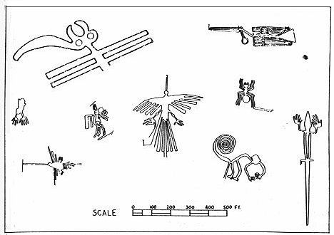
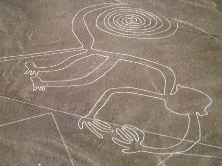
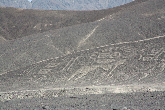
The Nazca Lines are giant sketches drawn in the desert of western Peru by ancient peoples. The drawings were created on such a large scale is such that the shapes can be readily discerned only from the air, leading to a variety of theories about their purpose.
The Nazca Lines were created in the time of the Nazca Indians, who flourished in the area from 200 BC to about 600 AD. Graves and ruins of their settlement have been found near the lines.
The lines would have taken a long time to create, perhaps several generations, and many people contributed to their creation. As to the purpose of the Nazca Lines, see below for some of the theories.
The area of the Peruvian desert in which the Nazca Lines were drawn is called the Pampa Colorada (Red Plain). It is 15 miles wide and runs some 37 miles parallel to the Andes and the Pacific Ocean. The desert is not sandy, but made of dark red surface stones and soil with lighter-colored subsoil beneath. The Lines were created by clearing away the darker upper layer to reveal the lighter subsoil.
It seems incredible that such simply-made drawings have survived for so many hundreds of years, and some have seen a mysterious element to this. But there is also a natural explanation: the surface is made of stone, not sand, and the climate of the area is such that there is practically no erosion. The Nazca peoples chose an excellent place for an enduring monument.
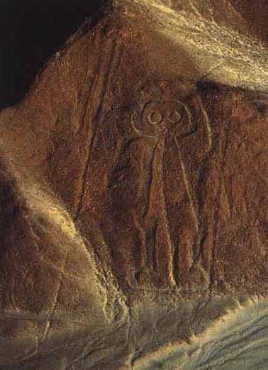
The Nazca Lines include straight lines and geometric shapes as well as stylized depictions of animals, humans and plants. The figures include:
  • monkey
  • condor
  • round-headed, rather friendly-looking human (known as "the astronaut")
  • another human figure
  • spider
  • hummingbird
  • hands
  • tree

Theories of the Nazca Lines mainly attempt to explain why these remarkable drawings were created, and some theories seek to address the "how" question as well. Especially in the earlier years of study, it was difficult for many anthropologists to believe that the ancient Nazca peoples could have created the Lines without help from a more advanced society - or species!
Perhaps the most famous theory of the Nazca Lines is that of Swiss writer Erich von Däniken. In his 1968 book Chariots of the Gods, he suggested that the lines were built by ancient astronauts as a landing field. He identifies the pictures as "signals" and the longer lines as "landing strips."
In 1977, Jim Woodman accepted that the Nazca people made the lines themselves, but puzzled over why they would make them so big that they couldn't even seen them. He hypothesized that the Nazca people used hot-air balloons for "ceremonial flights" to view their creations.
Woodman attempted to demonstrate the validity of his theory by constructing a hot-air balloon out of the materials that would have been available to the Nazca. Using cloth, rope and reeds, Woodman and his colleagues assembled the balloon then risked their lives on a balloon ride that reached a height of 300 feet. The balloon soon descended rapidly; the balloonists bailed out 10 feet above the desert before it crashed some distance away.
In recent years, the professional skeptic Joe Nickell has demonstrated that the drawings would not have been hard to accomplish with only the tools available to the ancient Nazca. Nickell has also shown that although the size of the figures suggests they were intended primarily for the enjoyment of the gods, the drawings can be appreciated from the ground as well.
The general consensus of archaeologists, anthropologists and scientists is that the Nazca Lines were created by the Nazca people themselves, without help from celestial visitors or aerial views. The figures drawn in the desert correspond with images found in other examples of Nazca art, such as pottery.
It is almost certain that the Nazca Lines had a sacred purpose, because: other artifacts of the Nazca culture show a preoccupation with death; other major monuments of the ancient world are known to be ritual in nature; and no plausible practical purpose has yet been discovered.
The Nazca Lines may have been ritual centers for helping the dead achieve immortality; they may have been an offering to the gods; or they could have been a major pilgrimage site.
We may never know why the Nazca peoples put so much time and care into a project that they could barely see. In spite of all that we have learned about them in recent years, the Nazca Lines remain a fascinating mystery.


If you like this post just click here Posted By crkota with No comments

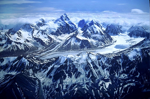
Denali National Park, Alaska


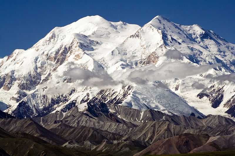
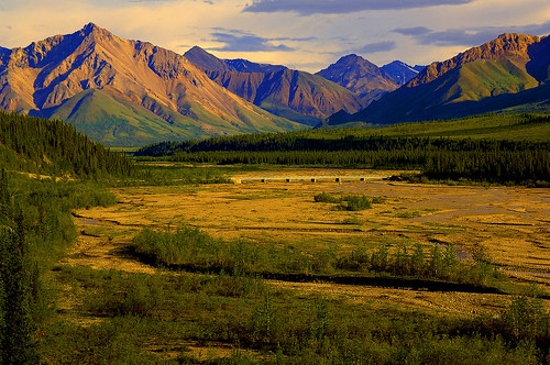
Denali National Park and Preserve’s dynamic glaciated landscape supports a diversity of wildlife, including grizzly bears, caribou, wolves, Dall sheep and moose. Birds and wildflowers grace summer slopes. Visitors enjoy sightseeing, backpacking, and mountaineering. Whether climbing or admiring, the crowning jewel is North America’s highest peak, the awe-inspiring, 20,320 foot Mount McKinley.

Mount McKinley National Park was established in 1917 to protect its large mammals, not because of majestic Mt. McKinley. In 1980, the boundary was expanded to include both the Denali caribou herds wintering and calving ground and the entire Mt. McKinley massif. This more than tripled the size of the park, and was renamed Denali National Park and Preserve. It was also designated an International Biosphere Reserve significant for the potential for subarctic ecosystem research.
Denali is an Athabaskan word meaning The High One. The mountain is officially named Mt. McKinley but is also referred to as Denali. Mt. McKinley is the highest peak in North America at 20,320 feet. It creates its own weather system and is often covered in clouds. Mt. McKinley is only visible about 1/3 of the time, so visitors to the park only have about a 30% chance of viewing Mt. McKinley. Denali is one of the greatest wildlife viewing areas in the world. Visitors have a chance of seeing grizzly bears, caribou, moose, Dall sheep, foxes, and wolves. Many smaller animals also inhabit the park such as arctic ground squirrels, hoary marmots, pikas, snowshoe hares, and beavers. For those interested in bird watching, there are a variety of birds that migrate to the park for the summer. The list includes arctic tern, American golden plover, long tailed jaeger, the surfbird, arctic warbler, the wheatear, willow ptarmigan, golden eagles, and ravens. Approximately 150 species live in and around the Denali area during the summer months.

For many people, this vast national park (covering 9,375 sq mi/24,280 sq km) between Anchorage and Fairbanks is the highlight of a trip to Alaska. It's a truly spectacular area, featuring the majestic 20,320-ft/6,299-m Mount McKinley (many Alaskans prefer the Tanaina name, Denali), the tallest mountain in North America. More than 155 species of birds and 37 species of mammals, including Dall sheep, caribou, grizzly bears, moose and wolves, inhabit the park. The landscape is at its most verdant during July and August. Beautiful fall colors (and fewer travelers) can be found in early September. The park is best seen as a three-night stop, especially if you are taking the train between Fairbanks and Anchorage. From mid-May to mid-September, the park offers interpretive talks and walks with guides, and all-day bus tours take visitors deep into the park. Be aware that the park road is restricted to tour- and shuttle-bus traffic for most of its 90-mi/145-km length. Book bus tours in advance: They fill up fast. Other park activities and facilities include fishing, river rafting, horseback riding and dogsledding demonstrations. Backcountry permits are available. Reservations need to be made months in advance to stay at the park's single lodge. Other lodging is available just outside the park's entrance, where you will also find restaurants and private parks for recreational vehicles.

Weather in Denali is extremely variable. Often changes in weather occur without warning. Many of our rangers tell visitors to expect sun, wind, rain, and clouds, and expect them all on the same day. Average summer temperatures range from 33 to 75 degrees Fahrenheit. While we hope it doesn't, it has been known to snow in July, so be prepared. Wearing layers of clothing makes it easy to regulate your body temperature. Also, you'll find that a good waterproof raincoat is invaluable. Winters can be extremely cold with temperatures ranging from -40 degrees Fahrenheit and below to high 20s on warm days. Specialized cold weather gear is necessary for mountaineering and winter visits.

source 1 2 3

If you like this post just click here Posted By crkota with No comments
  • Popular
  • Categories
  • Archives