"Enchin, a priest from Nara, was told in a vision to "Look for the clear water origin of the Yodo river" In a long search, he stumbled upon a place deep in the forest greenery where a mist, like a belt of white clouds, hung over a waterfall at the foot of Mt. Otowa." This famous temple received World Cultural Heritage Listing by UNESCO in December 1994. Kiyomizudera (The Clear Water Temple) is the main temple of the Hosso sect of Buddhism and has been destroyed and rebuilt many times in its twelve centuries of history. The Shinto Jishu Shrine is located here also. Kiyomizudera is said to have been constructed from 778 by Enchin, a buddhist priest, in honor of the Kannon Bosatsu (Bodhisattva of Mercy and Compassion). A bodhisattva is one who can achieve enlightenment but decides to remain on earth to assist others in achieving nirvana.
According to the legend, Enchin received a vision that said he would find at the source of the Yodo river, a clear source of water. During his search Enchin came across a hermit named Gyoei. Gyoei was a old priest practising ascetism and he gave Enchin a piece of wood possessed by the spirit of the Kannon Bosatsu. This was then carved into the likeness of the Kannon and Enchin then enshired the image in a small thatched roofed hut. This was the begining of Kiyomizudera. The legend also says that the hermit disappeared, and that when Enchin later found the hermit's sandals on top of the mountain, he realized that he had actually been speaking with a manifestation of the Kannon. On the other hand, the hermit may just have wanted some peace and quiet.
The legend continues that Sakanoue Tamuramaro, one of the emperor's leading generals came upon Enchin while deer hunting. The blood of a stag was thought to ease the pain the childbirth, and Tamuramarro's wife was about to give birth. Enchin spoke of the cruelty of killing animals (forbidden in the Buddhist tradition) and his speech so moved Tamuramaro that to repent, Tamuramaro underwrote the construction of a proper sanctuary. (Another story is that he disassembled his home and gave it to the temple, building a new house to replace it).
In 794 the emperor Kammu moved his capital to Kyoto and gave Tamuramaro his throne hall as a reward for his military service. As a devout worshipper of Kannon he proceeded to donate the building to Enchin for a new main hall. The building stood until 1629 until it was destroyed by fire. Today's Main Hall has roof made of cypress, not the traditional tile, in remembrance of originally being part of the emperor's palace. Most of the buildings today were rebuilt by Iemitsu Tokugawa, the 3rd shogun of the Tokugawa Shogunate, in 1633.
To get to the temple, you first make your way up Ninnen-zaka & Sannen-zaka walk, past the Omiyage shops until you reach the main gate of Kiyomizudera. The first thing you will see on the left is the old horse stables used by those going to offer their prayers to Kannon. Walking from there into the temple you will walk under the Nio-mon or Gate of the Deva Kings. The Deva Kings, along with Korean lion-dogs (koma-inu) protect the temple from any evil that may enter. The right Deva King has his mouth open, pronouncing "A", the first sound of Sanskrit while the other has his mouth closed, pronouncing "UN", the last sound. Thus, it is thought that the Deva Kings represent the complete teachings of Buddha.
Continuing past the Nio-mon, you go up a second flight of steps to the Sai-mon (West Gate). Two more Deva Kings stand guard at this eight pillared gate built in the early 17th century. To the gate's left one can see the Shoro (Bell Tower) built in 1596, though the temple's bell was cast in 1478. Above the flying brace of the tower one can see the imperial Chrysantheum crest.
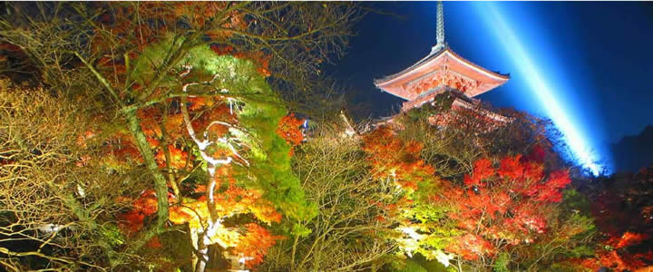
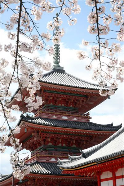
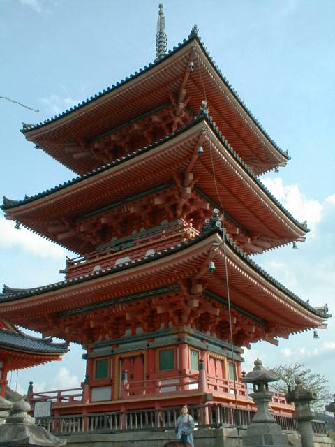
Behind Sai-mon rises Sanju-no-to (Three Storied Pagaoda), the tallest three-storied pagoda in Japan. Rebuilt in 1633 and repainted in 1987 in the original vermilion, the pagoda stands out against the dull brown of the other buildings. The bright color is typical of Buddhist temples, reflecting the Chinese architectural styles that came to Japan together with Buddhism.
After the pagoda is the Kyodo (sutra hall). This is where the sacred scriptures are kept. The hall contains images of the Buddhist deities of virtue (Monju) and wisdom (Fugen), along with a ceiling painting of a coiled dragon. On the right of the Kyodo is Zuigu-do or Jishin-in (Temple of Mercy) which was rebuilt in 1728. This was the favorite place of worship for Toyotomi Hideyoshi, and the temple still has some of his belongings.
Kanisan-do (Founder's Hall) comes next in line. It is also called the Tamura-do, to honor Tamuramaro. The hall was moved from Nagaoka to Kiyomizudera in the late 8th century and holds images of Gyoei the hermit, Enchin the priest, Tamuramaro and his wife, Takako.
Walking to the right of Kanisan-do will bring you upon Todoroki-mon. The middle gate contains yet another pair of Deva Kings, who protect the inner temple. This gate is called the "gate resounding to the call of the Buddha's teachings". In front of the gate is a hand washing trough with a dragon shaped water pipe. On the base of the trough is an owl design, which explains why the water from the dragon's mouth is often call "Owl Water".
Ahead of Todoroki-mon and to the left is Asakura-do. The hall was presented in 1633 by Akakura Sadakaga (1473-1512), son of the emperor Temmu and holds an Eleven-faced Kannon flanked by images of Bishamon-ten (god of wealth) and Jizo (guardian of children). On the side of the hall is a set of footprints of the Buddha. (In the early years of Buddhism images were not created of Buddha or the bodhisattvas therefore it was thought the footprints were a sufficient reminder of Buddha's way.) It is said that if one looks at the prints all their sins are forgiven. Have a closer look at the prints and you will see several symbols including a pair of fish, a floral crest, and a conch shell. If you look at the heel, a faint impression of the Buddhist Wheel of True Law can be seen. To the left of this building a small pond containing a small island can be seen. The island is called Benten-jima and is named after the Shinto goddess Benten whose shrine rests on the island.
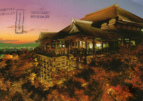
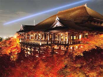
Directly past these structures you come to the main attraction of Kiyomizudera, the Hondo or Main Hall. Though the original structure, donated by Tamuramaro, was destroyed by fire in 1629 the present building is true to the Heian period style of architecture. Inside, the outer sanctuary is quite simple, decorated with 30 paintings donated by tradesmen during the 1633 rebuilding of the temple. The inner sanctuary is startlingly different. Many gold leaf images are displayed on raised black laquered platforms behind vermilion railings. Echin's image of Kannon is kept in a case with the 28 followers of Kannon by its side. On the corners of the platform the case rests on stand four Deva Kings, protecting all of the images. In the east of the hall is an image of Bishamon-ten and the west houses an image of Jizo. These two images, along with the Kannon image, are also said to have been carved by Enchin. If you are hoping to catch a glance at the Eleven-faced thousand-armed image you will have to wait until 2010. The image is only shown once every thirty three years (one year for every vow Kannon took to save mankind) and the last showing was in 1977. Fear not, pictures of Kannon, Jizo, and Bishamon are hung above the cases at all times.
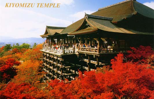
Making your way outside you come to the Butai (dancing stage). The stage is held up by wooden scaffolds that extends the stage 10 meters over a 12 meter cliff. This platform is one of the most photographed sites in Kyoto and immensely popular with Japanese. To the south you can see Koyasu-no-to (the easy child-birth pagoda), which contains an image of Koyasu Kannon. This view offers an excellent chance for a beautiful photograph, particularly in the autumn when the foliage is orange and red.
Up to the left is an unusual feature, the Shinto Jishu Shrine. The shrine is right in the middle of the temple, something that was not usual in Japan until the Meiji Restoration of 1868. After the Meiji Restoration, the government separated Shinto and Buddhism, often by destroying and/or physically relocating structures. Somehow the Jishu Shrine remained. Immensely popular with women, the god of love and good marriages resides in this shrine. It is worth the visit.
After you descend the stairs from Jishu Shrine, turn left and you will come to a line of buildings that lie beyond a large staircase. The first being Nishi-muki Jinzo, dedicated to the protector of the dead, travelers, and children. Next to Jinzo Shrine is Shaka-do which contains an image of the Buddha on a golden lotus flower. On one side of Shaka is an image of Monju (deity of wisdom) and on the other is Fugen (deity of virtue). Between Shaka-do and the next building, Amida-do, is a small structure containing 180 small images of Jizo. According to folklore if you come to pray at Hyakutai Jizo and see the face of your deceased child you can be sure that your child is at peace. The Amida-do has the traditional tiled roof of Buddhist temples and houses the image of Amida Nyorai (Buddha of the Western Paradise) with its hands in the traditional contemplation position. On May 15, 1188 Honen preached the doctrine of the Nenbutsu (Praise to the Buddha Amida) and thereby founded the cult of Amida and formed the Jodo sect of Buddhism. Five times per year a special Nenbutsu service takes place at Amida-do.
The final building is Okuno-in (Inner Temple). This site said to be the original home of the hermit Gyoei and the original crude structure that held Enchin's carvings of Kannon, Jizo, and Bishamon-ten. This location was also where Tomuramaro's sanctuary stood while it held the three images. This temple is dedicated to those images, even though they are now housed in the Hon-do. Beyond Okuno-in is the Nurete Kannon (Water-soaked Kannon); an image of Kannon in a water basin. To pour water over the image is considered an act of purification.
Below you will see people reaching out to Otowa-no-taki (Sound of Feathers Waterfall) with long wooden poles to fill cups with the "Clear Water" from the falls. On busy Sunday afternoons, there will be a long queue. At times you will also happen across people who stand beneath the falls praying to Fudo Myoo (God King of Fire who punishes evil-doers). The water is also said to have the power to prevent illness, so grab a cup and have a nice long drink.
In the north of the temple grounds is the Kita So-mon (North Gate) which leads to the main sub-temple of Joju-in. This temple was originally a private temple for the emperor Go-Kashiwabara (reign 1500-1526). From November 1st to November 10th the garden of the temple superior is open to the public. The creators of the garden, Soami (1455-1525) and Kobori Enshu (1579-1647) are two of Japan's most famous landscape gardeners. Viewed from the study of Joju-in the garden appears much larger than it acutally is. This is achieved by "borrowing scenery" from the nearby hills making it appear as part of the garden. The garden contains a pond with a large stone resembling the formal hat of the Heian period (eboshi) and two islands. The water basin, donated by Toyotomi Hideyoshi in the 1590's, is called Furisode (sleeve basin), so named because the stone's shape is similar to the long sleeves of a girl's kimono.
Heading back to the entrance of the temple from Joju-in you will come to Dai-kodo (Great Lecture Hall). Built in 1978 to commemerate the 1200th aniversary of the founding of the temple, this building has a central chamber called Taho-kaku (Tower of Many Treasures) and two wings. Within the Taho-kaku are the Bussoku-seki (Buddha's Footprints Stone) measuring four meters long. The four walls surrounding the footprints have 4076 images of the four Buddhas. To the north are images of Taho-Nyorai, to the south Shaka-Nyorai, the east Yakushi-Nyorai, and the west wall shows the images of Amida-Nyorai. The upper chamber of the tower enshrines some of the ashes of the historic Buddha.
Kiyomizudera is situated on approximately 130,000 square meters and consists of over 30 structures.
Admission Times / Hours Open: 6:00 - 18:00 (some parts close around 4)
Time Needed for Tour: About 40 minutes (at least)
Days Closed / Facilities Closed: Open daily
Cost of Admission: Main facilities (Main Hall, Balcony) 300 Yen
Address : 294 1-chome, Kiyomizu, Higashiyama-ku
Tel : 075-551-1234 Fax : 075-551-1287
How to get to Kiyomizudera?
1:
From Kyoto Station:
Take bus 202, 206, or 207 and get off at Kiyomizu-michi or Gojo-zaka. From there make your way up hill past the shops and once you reach the top you will be in front of the temple.
2:
From Okazaki:
Take the Kaisoku (Express) from JR Okazaki Station to JR Mikawa Anjo (10 minutes) or JR Nagoya Station (28 minutes). Change to a west bound Kodama shinkansen. Take bus 202, 206, or 207 and get off at Kiyomizu-michi or Gojo-zaka. From there make your way up hill past the shops and once you reach the top you will be in front of the temple. As of writing, the tickets cost XXXX yen one way and the journey takes about XXXX minutes not including the train change.




 According to Greek myth, there was only one Minotaur - the child of Pasiphae, Queen of Crete and wife of King Minos, and a white bull sent by the sea god Poseidon.
 King Minos trapped his stepson in the great Labyrinth below the palace of Knossos and kept the Minotaur satisfied by feeding him 14 young men and women exacted as tribute from the Athenians. According to one version of legend, this tribute was made every nine years, suggesting the Minotaur could live off stockpiled nutrient reserves for long periods of time. However, other versions suggest the tribute was annual, or that Minoans were slaughtered instead of Athenians eight years out of nine.
 Many observers said that the Minotaur was invulnerable to any weapon but his own horn driven through his brain. This is probably an exaggeration, although a Minotaur's size, speed, strength and ferocity, combined with a pair of deadly horns, must have made it a formidable adversary.
 eruption and subsequent tidal wave are thought to have been responsible. By 1100 BCE, the Minoan civilization had faded.


