Get widget

News

All kinds of news around the world in one place!

Studies

Explore with us and enjoy in that!

Encyclopedia

Start with us a journey through world of knowledge!

Travel

The world is beautiful. Let's peek into some magnificent places, and see what they offer!

Entertainment

Fun - because we have the right to be happy!

Lifestyle

Our life is adventure. Enjoy in every moment of that!

TOP 10

Amazing lists of incredible things!

Band of Holes near Pisco Valley, Peru

These strange holes, stretching for a mile over uneven mountain terrain, were here for so long that the local people have no idea who made them, or why. Funny thing is no one really saw the big picture until the area was seen from the air.


Thousands of man-sized holes are carved into the barren rock near Pisco Valley, Peru on a plain called Cajamarquilla.
Click on the image to enlarge.

Satellite photo of the Pisco Valley with marked location of
the "Band of Holes" . Click on the image to enlarge.
Archeologists have speculated they were dug to store grain in. Two problems with this, say the folks thinking out of the box: there were a lot easier ways to create storage containers than the hard work and decades it must have taken to chip out all of these, and it would have made more sense, if these were to store grain, to build several huge chambers.
Ok, said the archeologists. Perhaps they were used as one-person tombs? Vertical graves of some sort? But no bones, artifacts, scraps, inscriptions, jewelry...not even a tooth or strand of hair has been found in them. They have no covers to seal them as you might a tomb and no sacred history or even myth was passed down to label them as such. Some sections have holes in rigid and perfect precision; some run in rows that curve up in arches, some staggered lines. They vary in depth to about 6-7 feet deep yet some are merely shallow indents as if not completed - though surrounded by those that are. To date, no one has a clue why they're here, who made them or what they were.
Satellite photo of the "Band of Holes" near Pisco Valley.
Note: The location of the band of holes is highlighted brown.
Click on the image to enlarge.
Even von Daniken's work begins to take on a realness when one finds an old National Geographic from 1933 corroborating the "Band of Holes," that he personally inspected a few years ago. Each hole is a meter wide and just as deep. There are eight holes spanning 24 meters in width, marching in repetitive uniform fashion, from the Pisco Valley rolling over a mile through mountain terrain -- finally disappearing in the misty mass of Peru. These holes remind this old West Texas boy of the traces left by a massive drilling rig moving along methodically, testing the geology of the Andes for precious metals. Lasers have also left such tracings in the ground. Archaeologists say they represented defensive positions or graves for the ancient ones, except why would you bury anyone on a slope in rocky soil at more than a 45-degree angle? If you look at the most northern part of the band, you will notice that it ends within unnaturally darkened area (it almost looks like a remnants of an explosion)... see the photo below:
Strangely dark area where the "band of holes" ends.
Click to enlarge
Few miles east from the band, satellite photo shows structures that look like a remnants of an ancient settlement (these formations do not look natural and there is nothing similar in the entire area): 13 42'36.80" S, 75 51'4.07" W
Remnants of an ancient city?
Click on the image to enlarge
For the reference here is satellite photo of Machu Picchu:
Ruins of Machu Picchu, Peru (click to enlarge).

If you like this post just click here Posted By crkota with No comments

The Nazca Lines, Peru

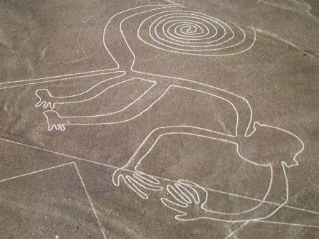
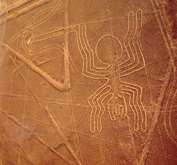
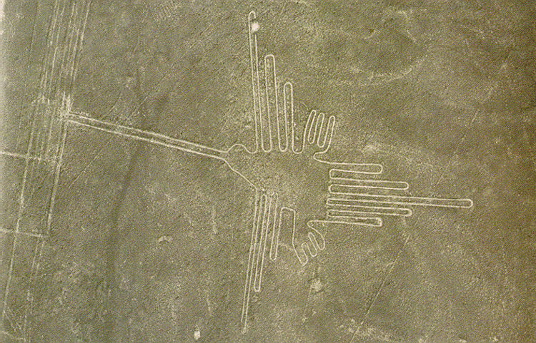
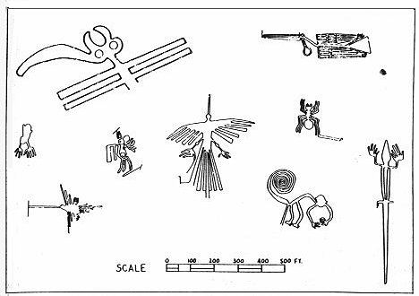
The Nazca Lines are giant sketches drawn in the desert of western Peru by ancient peoples. The drawings were created on such a large scale is such that the shapes can be readily discerned only from the air, leading to a variety of theories about their purpose.
The Nazca Lines were created in the time of the Nazca Indians, who flourished in the area from 200 BC to about 600 AD. Graves and ruins of their settlement have been found near the lines.
The lines would have taken a long time to create, perhaps several generations, and many people contributed to their creation. As to the purpose of the Nazca Lines, see below for some of the theories.
The area of the Peruvian desert in which the Nazca Lines were drawn is called the Pampa Colorada (Red Plain). It is 15 miles wide and runs some 37 miles parallel to the Andes and the Pacific Ocean. The desert is not sandy, but made of dark red surface stones and soil with lighter-colored subsoil beneath. The Lines were created by clearing away the darker upper layer to reveal the lighter subsoil.

It seems incredible that such simply-made drawings have survived for so many hundreds of years, and some have seen a mysterious element to this. But there is also a natural explanation: the surface is made of stone, not sand, and the climate of the area is such that there is practically no erosion. The Nazca peoples chose an excellent place for an enduring monument.
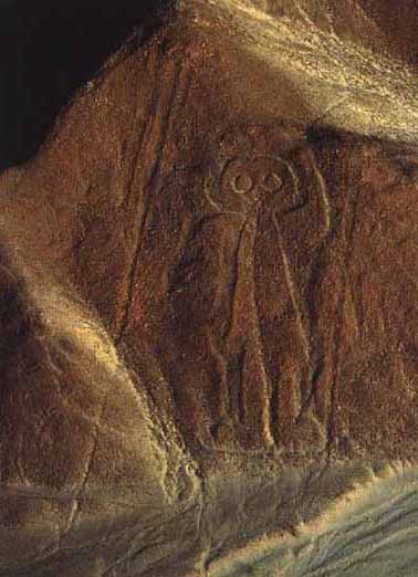
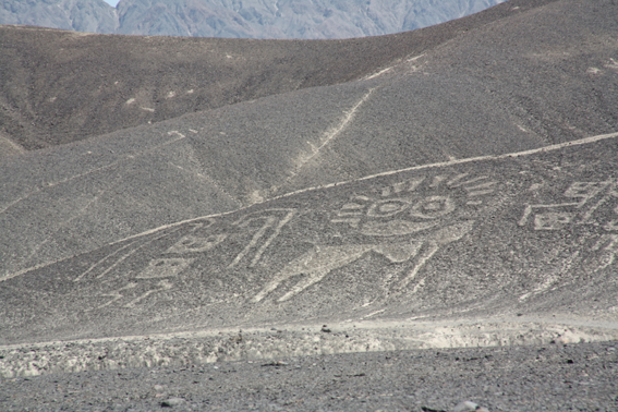
The Nazca Lines include straight lines and geometric shapes as well as stylized depictions of animals, humans and plants. The figures include:
  • monkey
  • condor
  • round-headed, rather friendly-looking human (known as "the astronaut")
  • another human figure
  • spider
  • hummingbird
  • hands
  • tree

Theories of the Nazca Lines mainly attempt to explain why these remarkable drawings were created, and some theories seek to address the "how" question as well. Especially in the earlier years of study, it was difficult for many anthropologists to believe that the ancient Nazca peoples could have created the Lines without help from a more advanced society - or species!
Perhaps the most famous theory of the Nazca Lines is that of Swiss writer Erich von Däniken. In his 1968 book Chariots of the Gods, he suggested that the lines were built by ancient astronauts as a landing field. He identifies the pictures as "signals" and the longer lines as "landing strips."
In 1977, Jim Woodman accepted that the Nazca people made the lines themselves, but puzzled over why they would make them so big that they couldn't even seen them. He hypothesized that the Nazca people used hot-air balloons for "ceremonial flights" to view their creations.
Woodman attempted to demonstrate the validity of his theory by constructing a hot-air balloon out of the materials that would have been available to the Nazca. Using cloth, rope and reeds, Woodman and his colleagues assembled the balloon then risked their lives on a balloon ride that reached a height of 300 feet. The balloon soon descended rapidly; the balloonists bailed out 10 feet above the desert before it crashed some distance away.
In recent years, the professional skeptic Joe Nickell has demonstrated that the drawings would not have been hard to accomplish with only the tools available to the ancient Nazca. Nickell has also shown that although the size of the figures suggests they were intended primarily for the enjoyment of the gods, the drawings can be appreciated from the ground as well.
The general consensus of archaeologists, anthropologists and scientists is that the Nazca Lines were created by the Nazca people themselves, without help from celestial visitors or aerial views. The figures drawn in the desert correspond with images found in other examples of Nazca art, such as pottery.
It is almost certain that the Nazca Lines had a sacred purpose, because: other artifacts of the Nazca culture show a preoccupation with death; other major monuments of the ancient world are known to be ritual in nature; and no plausible practical purpose has yet been discovered.
The Nazca Lines may have been ritual centers for helping the dead achieve immortality; they may have been an offering to the gods; or they could have been a major pilgrimage site.
We may never know why the Nazca peoples put so much time and care into a project that they could barely see. In spite of all that we have learned about them in recent years, the Nazca Lines remain a fascinating mystery.


If you like this post just click here Posted By crkota with No comments

Denali National Park, Alaska


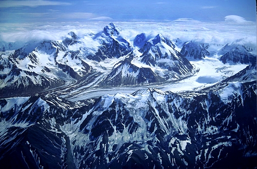
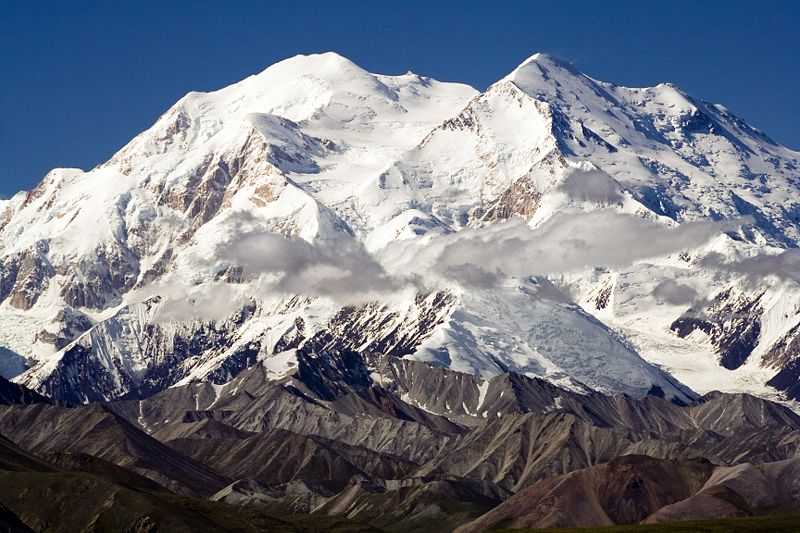
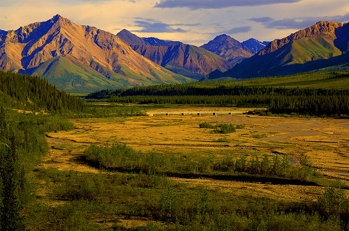
Denali National Park and Preserve’s dynamic glaciated landscape supports a diversity of wildlife, including grizzly bears, caribou, wolves, Dall sheep and moose. Birds and wildflowers grace summer slopes. Visitors enjoy sightseeing, backpacking, and mountaineering. Whether climbing or admiring, the crowning jewel is North America’s highest peak, the awe-inspiring, 20,320 foot Mount McKinley.

Mount McKinley National Park was established in 1917 to protect its large mammals, not because of majestic Mt. McKinley. In 1980, the boundary was expanded to include both the Denali caribou herds wintering and calving ground and the entire Mt. McKinley massif. This more than tripled the size of the park, and was renamed Denali National Park and Preserve. It was also designated an International Biosphere Reserve significant for the potential for subarctic ecosystem research.
Denali is an Athabaskan word meaning The High One. The mountain is officially named Mt. McKinley but is also referred to as Denali. Mt. McKinley is the highest peak in North America at 20,320 feet. It creates its own weather system and is often covered in clouds. Mt. McKinley is only visible about 1/3 of the time, so visitors to the park only have about a 30% chance of viewing Mt. McKinley. Denali is one of the greatest wildlife viewing areas in the world. Visitors have a chance of seeing grizzly bears, caribou, moose, Dall sheep, foxes, and wolves. Many smaller animals also inhabit the park such as arctic ground squirrels, hoary marmots, pikas, snowshoe hares, and beavers. For those interested in bird watching, there are a variety of birds that migrate to the park for the summer. The list includes arctic tern, American golden plover, long tailed jaeger, the surfbird, arctic warbler, the wheatear, willow ptarmigan, golden eagles, and ravens. Approximately 150 species live in and around the Denali area during the summer months.

For many people, this vast national park (covering 9,375 sq mi/24,280 sq km) between Anchorage and Fairbanks is the highlight of a trip to Alaska. It's a truly spectacular area, featuring the majestic 20,320-ft/6,299-m Mount McKinley (many Alaskans prefer the Tanaina name, Denali), the tallest mountain in North America. More than 155 species of birds and 37 species of mammals, including Dall sheep, caribou, grizzly bears, moose and wolves, inhabit the park. The landscape is at its most verdant during July and August. Beautiful fall colors (and fewer travelers) can be found in early September. The park is best seen as a three-night stop, especially if you are taking the train between Fairbanks and Anchorage. From mid-May to mid-September, the park offers interpretive talks and walks with guides, and all-day bus tours take visitors deep into the park. Be aware that the park road is restricted to tour- and shuttle-bus traffic for most of its 90-mi/145-km length. Book bus tours in advance: They fill up fast. Other park activities and facilities include fishing, river rafting, horseback riding and dogsledding demonstrations. Backcountry permits are available. Reservations need to be made months in advance to stay at the park's single lodge. Other lodging is available just outside the park's entrance, where you will also find restaurants and private parks for recreational vehicles.

Weather in Denali is extremely variable. Often changes in weather occur without warning. Many of our rangers tell visitors to expect sun, wind, rain, and clouds, and expect them all on the same day. Average summer temperatures range from 33 to 75 degrees Fahrenheit. While we hope it doesn't, it has been known to snow in July, so be prepared. Wearing layers of clothing makes it easy to regulate your body temperature. Also, you'll find that a good waterproof raincoat is invaluable. Winters can be extremely cold with temperatures ranging from -40 degrees Fahrenheit and below to high 20s on warm days. Specialized cold weather gear is necessary for mountaineering and winter visits.

source 1 2 3

If you like this post just click here Posted By crkota with No comments

Perseid meteor shower

A bright moon will drown out fainter meteors...

The moon will be at last quarter the night of Aug. 13 and it will be at a rather bright waning gibbous phase a night or two earlier, seriously hampering observation of the peak of the Perseids, predicted to occur late on the nights of Aug. 11 and 12.

Moonrise on Aug. 11 comes at around 10:20 p.m., while on Aug. 12 it's around 10:50 p.m. The moon will be hovering below and to the left of the Great Square of Pegasus these nights and not all that far from the constellation Perseus, from where the meteors will appear to emanate (hence the name "Perseid").

Perseus, does not begin to climb high up into the northeast sky until around midnight; by dawn it's nearly overhead. But bright moonlight will flood the sky through most of those two key nights and will certainly play havoc with any serious attempts to observe these meteors.


Facts

Every August the skies above the Northern Hemisphere are peppered with little bits of space debris that create the Perseid meteor shower. The debris is tiny, ancient and packs a wallop. Find out why.

Perseid meteoroids (which is what they're called while in space) are fast. They enter Earth's atmosphere (and are then called meteors) at roughly 133,200 mph (60 kilometers per second) relative to the planet. Most are the size of sand grains; a few are as big as peas or marbles. Almost none hit the ground, but if one does, it's called a meteorite.

Comet Swift-Tuttle, whose debris creates the Perseids, is the largest object known to make repeated passes near Earth. Its nucleus is about 6 miles (9.7 kilometers) across, roughly equal to the object that wiped out the dinosaurs.

Back in the early 1990s, astronomer Brian Marsden calculated that Swift-Tuttle might actually hit Earth on a future pass. More observations quickly eliminated all possibility of a collision. Marsden found, however, that the comet and Earth might experience a cosmic near miss (about a million miles) in 3044.

When a Perseid particle enters the atmosphere, it compresses the air in front of it, which heats up. The meteor, in turn, can be heated to more than 3,000 degrees Fahrenheit (1,650 Celsius). The intense heat vaporizes most meteors, creating what we call shooting stars. Most become visible at around 60 miles up (97 kilometers). Some large meteors splatter, causing a brighter flash called a fireball, and sometimes an explosion that can often be heard from the ground.

Comet Swift-Tuttle has many comet kin. Most originate in the distant Oort cloud, which extends nearly halfway to the next star. The vast majority never visit the inner solar system. But a few, like Swift-Tuttle, have been gravitationally booted onto new trajectories, possibly by the gravity of a passing star long ago.

Perseid meteoroids (and if you've been following along, you know these are things in space before they hit Earth's atmosphere) are anywhere from 60 to 100 miles apart, even at the densest part of the river of debris left behind by comet Swift-Tuttle. That river, in fact, is more like many streams, each deposited during a different pass of the comet on its 130-year orbit around the Sun. The material drifts through space and, in fact, orbits the Sun on roughly the same path as the comet while also spreading out over time.

As Earth rotates, the side facing the direction of its orbit around the Sun tends to scoop up more space debris. This part of the sky is directly overhead at dawn. For this reason, the Perseids and other meteor showers (and also random shooting stars in general) are usually best viewed in the predawn hours.

Comet Swift-Tuttle was last seen in 1992, an unspectacular pass through the inner solar system that required binoculars to enjoy. Prior to that, it had last been seen in the year it was "discovered" by American astronomers Lewis Swift and Horace Tuttle, 1862. Abraham Lincoln was President.

Swift-Tuttle's orbit has been traced back nearly 2,000 years and is now thought to be the same comet that was observed in 188 AD and possibly even as early as 69 BC.

Swift-Tuttle is due back in 2126 (as you know now, it won't hit us) and astronomers think it might become a spectacular naked-eye comet like Hale-Bopp. If historical calculations are correct (see Fact #9) then the 2126 appearance will mark the comet's 3rd millennium of human observation, assuming someone is in fact around to see it.

source 1 2

If you like this post just click here Posted By crkota with No comments
  • Popular
  • Categories
  • Archives